
Marian Court - Summer Drop-in Exhibition
Overview
In 2020, the Council received planning consent for the Marian Court scheme. The design has since had to be amended to respond to changes in building regulations, including fire escape and ventilation requirements, updated Mayoral and Hackney planning policies, and the need to bring costs within a viable range following the impact of inflation in the early 2020s.
Following engagement and consultation during 2025 and 2026, we are feeding back in response to questions raised and sharing some more material / design information about the proposed scheme. For further details of consultation and engagement to date, please click the link below.
Consultation to Date
- Online consultation from 27 November to 24 December 2025 and 27 February to 24 March 2026. 86 responses received and reported on from two questionnaires.
- Two drop-in exhibitions were held at the local Jack Dunning Centre on 27 November 2025 and 22 January 2026.
- Three street exhibitions were held in visible locations around the Marian Court site on Saturday 7 March 2026, with two sessions, and Monday 9 March 2026. These were made public in a letter to all local residents and businesses from the Council on 17 February 2026.
- A range of meetings and exchanges were conducted with key local stakeholders and Tenant and Resident Associations active in the area.
- Meetings were held in June 2026 with residents from the following areas to discuss the amendments and the Council's initial response to consultation:
- Mehetabel Road and Isabella Road
- Homerton High Street and Furrow Lane
Find out more
The Council recognises that some proposed changes may feel significant to residents. We are holding two drop-in exhibitions where we will explain the proposed changes, how concerns raised have been addressed, and where refinements have been made.
|
Date |
Time |
Location |
|
Saturday 27 June 2026 |
10am-1pm |
Banister House Community Hall, |
|
Tuesday 30 June 2026 |
5-8pm |
Jack Dunning Estate Community |
This information presented at the drop-in sessions is also included below under 'Key questions and responses'.
Key questions and responses
Through the process of consultation and engagement, 18 key questions were identified. These are shown below with considered answers - click on the question to view the response.
If you would like clarification on any the questions below, please contact: consultation@hackney.gov.uk.
Q1 - What guides the design of the amended scheme?
Design Approach
The scheme is informed by the key design ambitions that generated the consented scheme. These are:
- To create a connected part of the neighbourhood, rather than a separate or inward-facing estate
- To provide a new east-west link through the estate linking Bridge House Courtyard to Hackney Central Station
- To create a permeable scheme with multiple access and egress points
- To design a high-quality, high-density scheme appropriate to its location and to London Plan and Council policies promoting the intensified use of such sites to exploit the very good public transport links (overground rail and buses)
The diagram above shows how the scheme connects with its surrounding neighbourhood and city context.
Key components are the large local schools (Hackney City Academy, Cardinal Pole School and St John & St James Primary School) and also Homerton High Street and local green spaces and play areas in the locality. In addition, in terms of local context, the conservation area which stands immediately to the west of the scheme is recognised and responded to in terms of height and massing.
The scheme was amended in part to accord with the revised London Plan and Council Planning Policy as well as Government regulations.
Approach to the delivery of affordable and social rent housing:
- The Council builds mixed tenure to create/maintain mixed neighbourhoods
- The profits from selling private and shared ownership homes pay for social rent homes.
- Homes in parts of the borough that generate higher sales, cross-subsidise homes in other parts of the borough
Reducing costs and making it easier to build:
Looking to -
- Reduce number of lift/stair cores
- Simplify site levels
- Use smaller pieces of concrete
- Reduce complexity
Design ‘efficiency’ Net:Gross -
- NIA:GIA – getting the best ratio possible
- Net internal area (NIA) = all internal areas that can be lived in, sold or rented
- Gross internal area (GIA) = all internal area including communal parts (such as stairs)
The overall aim is to maximise the areas that people live in
Cross-subsidy model
- Roughly two private sale homes were needed for one social rent home prior to the inflation spike in the early 2020s. The number of private sales homes is greater now as a result of this
- GLA grant helps, but it is not enough to eliminate the need to sell private homes
- The 4 additional homes for social rent cost approx. £1.5M more
Avoiding -
- Single aspect homes
- Poor quality materials
- Quick wins that add long term costs
- Significant impact on neighbours
Building Safety Act
- The Building Safety Act has impacted design efficiency, as more ancillary spaces are required to support housing
Block changes
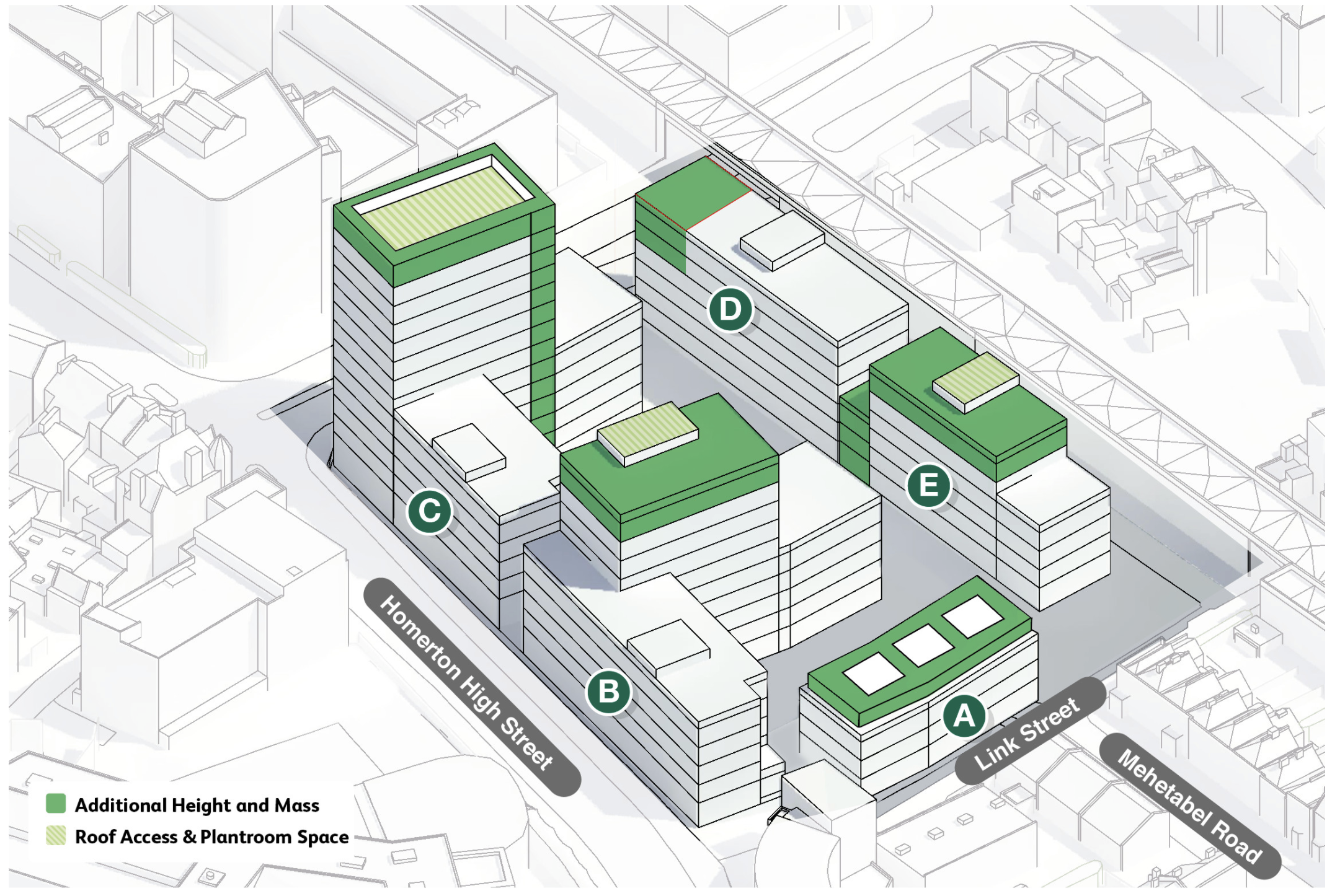
See diagram below where additional height and mass are shown in green. This compensates for space lost to new fire escape cores and circulation space while also helping to restore viability and subsidies for social rent housing:
Block A:
- Now flats and duplexes (not fewer town houses)
- 3 roof pavilions now 1 set-back storey
Block B:
- 1 storey added to Block B2
- Longer and wider/deeper
- Deck access introduced
Block C:
- Sky frame added to Block C2
- All blocks longer and wider/deeper
- Deck access introduced
Blocks D & E:
- Combine into 6 and 4 storeys
- Relocated play space (basketball court)
- Deck access introduced
Q2. How much larger is the amended scheme?
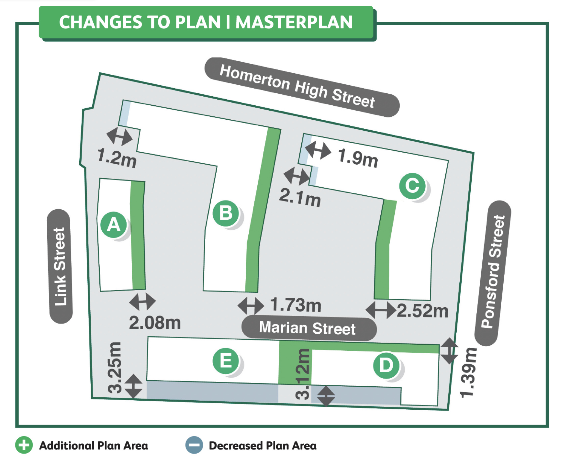
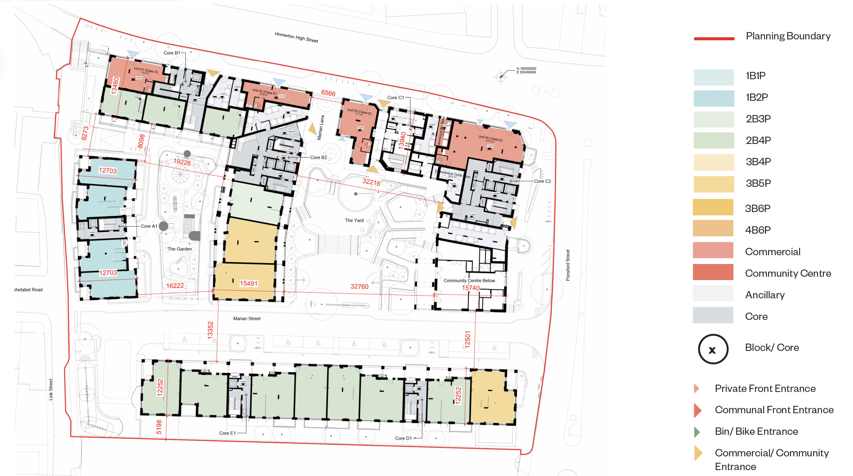
The key take away is that the scheme is approximately 9% larger in floor area terms than the consented scheme. The plan diagram at the bottom provides an overall, dimensioned summary (green areas being additional).
The current proposals look to retain a similar footprint to the 2020 consented scheme with adjustments where required to incorporate the new dwelling layouts.
Blocks D and E were also reduced in width to move away from the southern boundary (the railway line) and to avoid an existing sewer.
Overall the amended scheme contains 3 more homes.
2020 Scheme: Total Floor Area - 19,457 m2
2025 Scheme: Total Floor Area - 21,232 m2
(Please see answer to Q4 for further information on amended building heights and mass).
The diagram below shows the 'footprint' of the 2020 consented scheme and the proposed 2025 amended scheme showing that Blocks A, B and C have all increased in width while Blocks D and E have reduced widths.
Q3. Will the number and type of homes change?
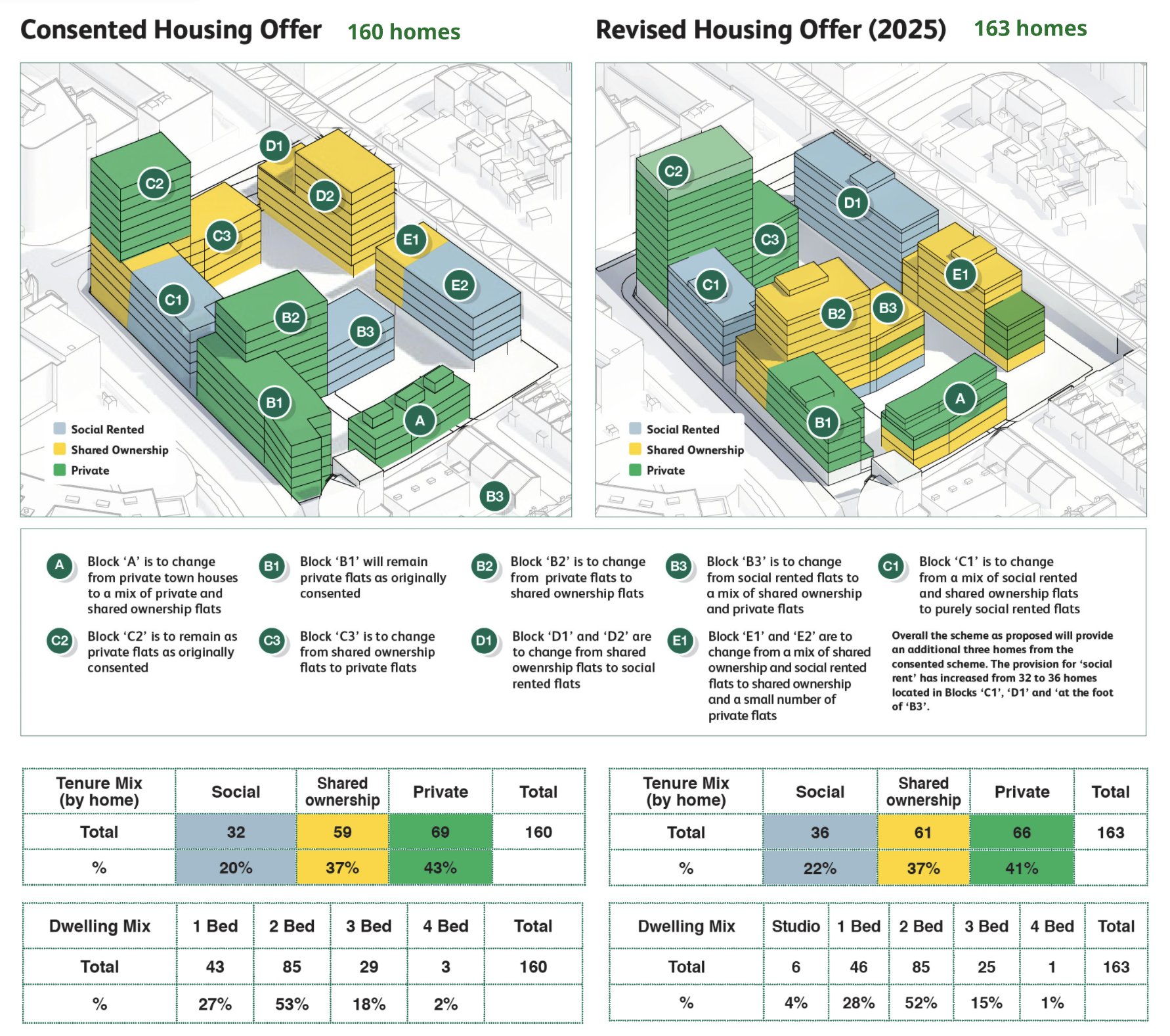
Overall there will be three more homes.
The proposed changes are captured in the diagrams and tables above. In essence the changes are as follows:
- Studio flats have now been introduced and they make up 4% of the mix
- 1 Bed flats have increased by 1% (of the total mix)
- 2 Bed flats have decreased by 1%
- 3 Bed flats have decreased by 3%
- 4 Bed flats have decreased by 1%
Amended Housing Offer - Mix
There have also been changes to the distribution of tenures across the estate. The intention remains to create a mixed and balanced community, with homes designed to be ‘tenure blind’, so that affordable and private homes are not distinguishable by appearance.
The 3D diagrams above describe how the housing tenure distribution was conceived within the 2020 consented scheme and as currently proposed. The ground floor plan of the amended scheme below shows a typical distribution of flat sizes.
Q4. Are the heights of the buildings changing and if so, have the proposed heights and mass been assessed and do they cohere with London Plan guidelines?
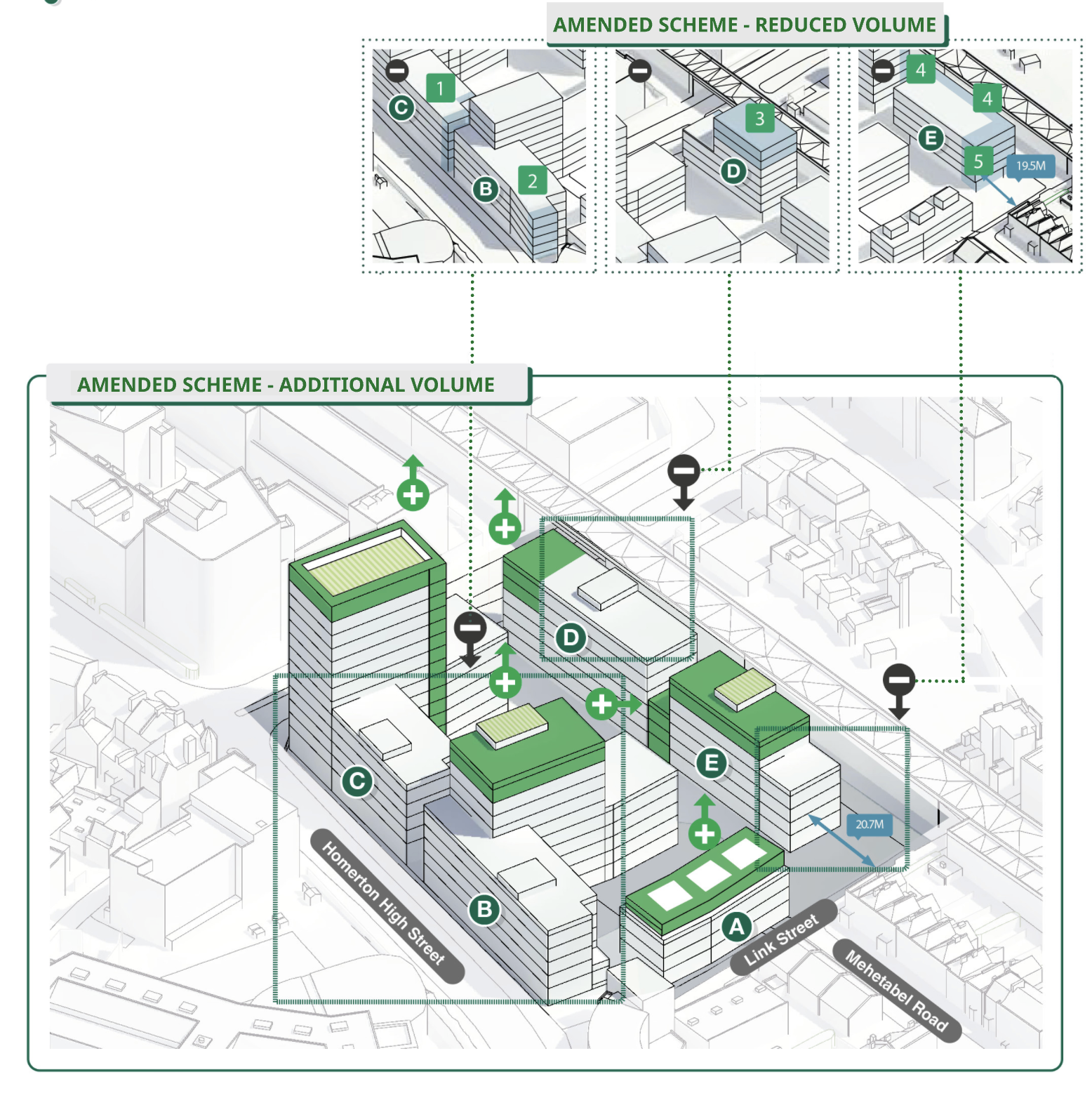
While changes have been proposed to the heights of the blocks, the overall massing strategy has had to retain similar principles to the 2020 consented scheme to be able to sit within a Section 73 application. Moving towers towards the railway, as some feedback suggested, would constitute a significant change which would require a new planning application, significantly delaying new home delivery and escalating costs. The diagram immediately above shows where floors and mass have been added (in green). There are also some areas where floors and mass have been removed. These are shown in blue in the 'Amended Scheme - Reduced Volume' diagram.
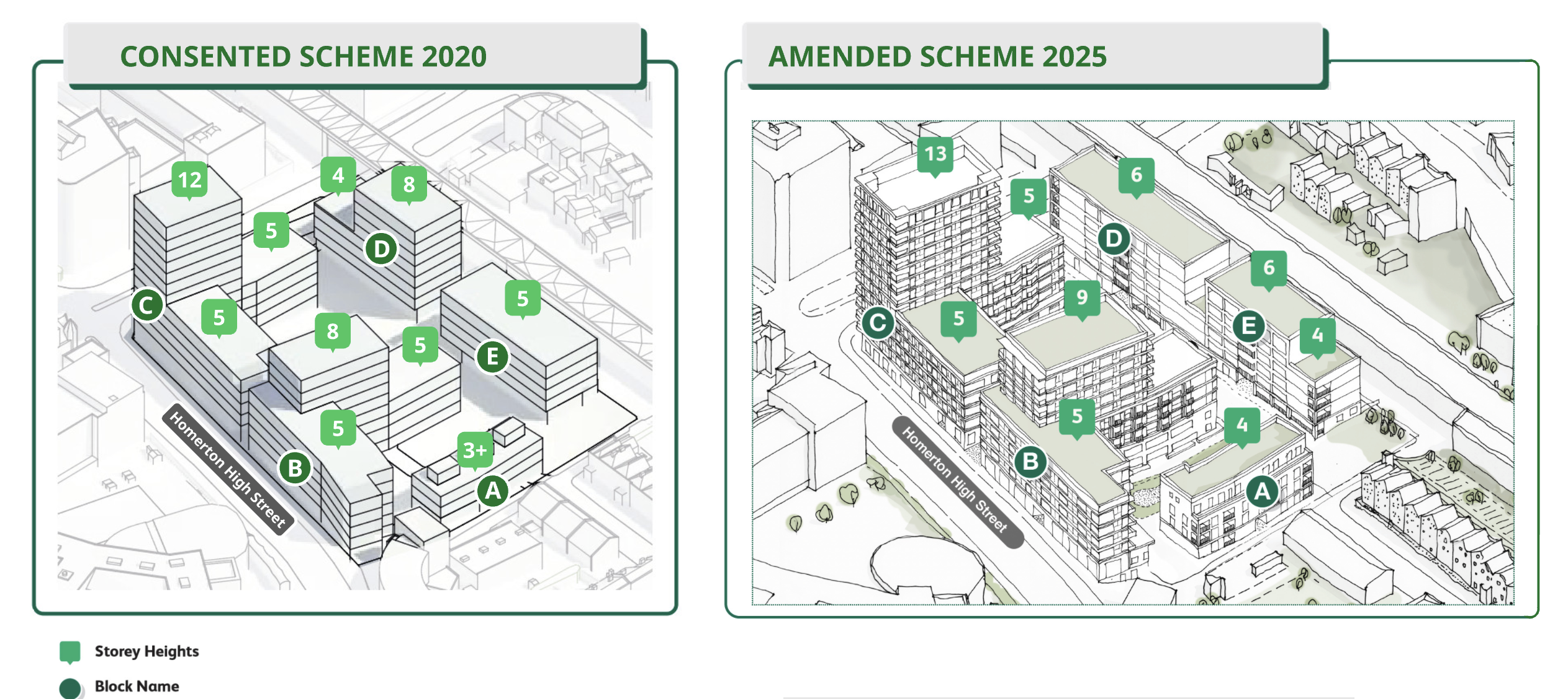
The key additional floors are:
- An additional set-back floor to Block A
- An additional floor to Block B
- An extra floor and a quarter to Block C in the form of an elevational screen around roof top plant
- Two extra floors inserted in the former stepped down block, Block D, facing Ponsford Street
- An additional floor over part of Block E.
Key reductions are:
- 2 floors removed from Block D (previously 8 floors)
- Approx 3m. wide strip removed from Blocks D and E
- Further reductions through reduced lengths of Blocks B and C
Statement from Planning Consultants, Tibbalds:
“The scheme has been designed to conform to latest London and Hackney planning policies on density, building height and massing.
The London Plan promotes a design-led approach to density, supporting higher-density development in well-connected locations with good access to jobs, services and public transport (see policies GG2, D2 and D3). Marian Court is located within the Dalston–Hackney Central–Homerton–Hackney Wick–Stratford corridor identified by Hackney’s Local Plan 2033. Marian Court is well suited to higher-density development.
The revised proposals increase density compared to the 2020 consent. They retain the key design principles of the approved scheme, delivering high-quality architecture and public realm informed by the site's character, opportunities and constraints. The proposals make efficient use of the site while remaining appropriate to its context.
The approach to building heights also follows London and Hackney policy, which requires a design-led assessment of taller buildings and their impacts. The London Plan outlines that Boroughs should establish appropriate locations for taller buildings, and what form is appropriate (see Policy D9). Hackney’s Local Plan requires exceptional design quality that responds positively to local character, heritage assets and the public realm and landscape, the incorporation of sustainable and inclusive design principles, and to ensure that any taller buildings are appropriately justified and enhance both the streetscape and wider townscape (see Policy LP1).
The revised scheme retains the approved height strategy, with taller buildings on Homerton High Street stepping down towards neighbouring residential streets and the Conservation Area. Block A includes a recessed upper floor and lower building heights to respond to the surrounding two-storey homes and provide an appropriate transition in scale.
Assessments of daylight, sunlight and heritage impacts confirm that the proposed heights and massing are acceptable and comply with planning policy.”
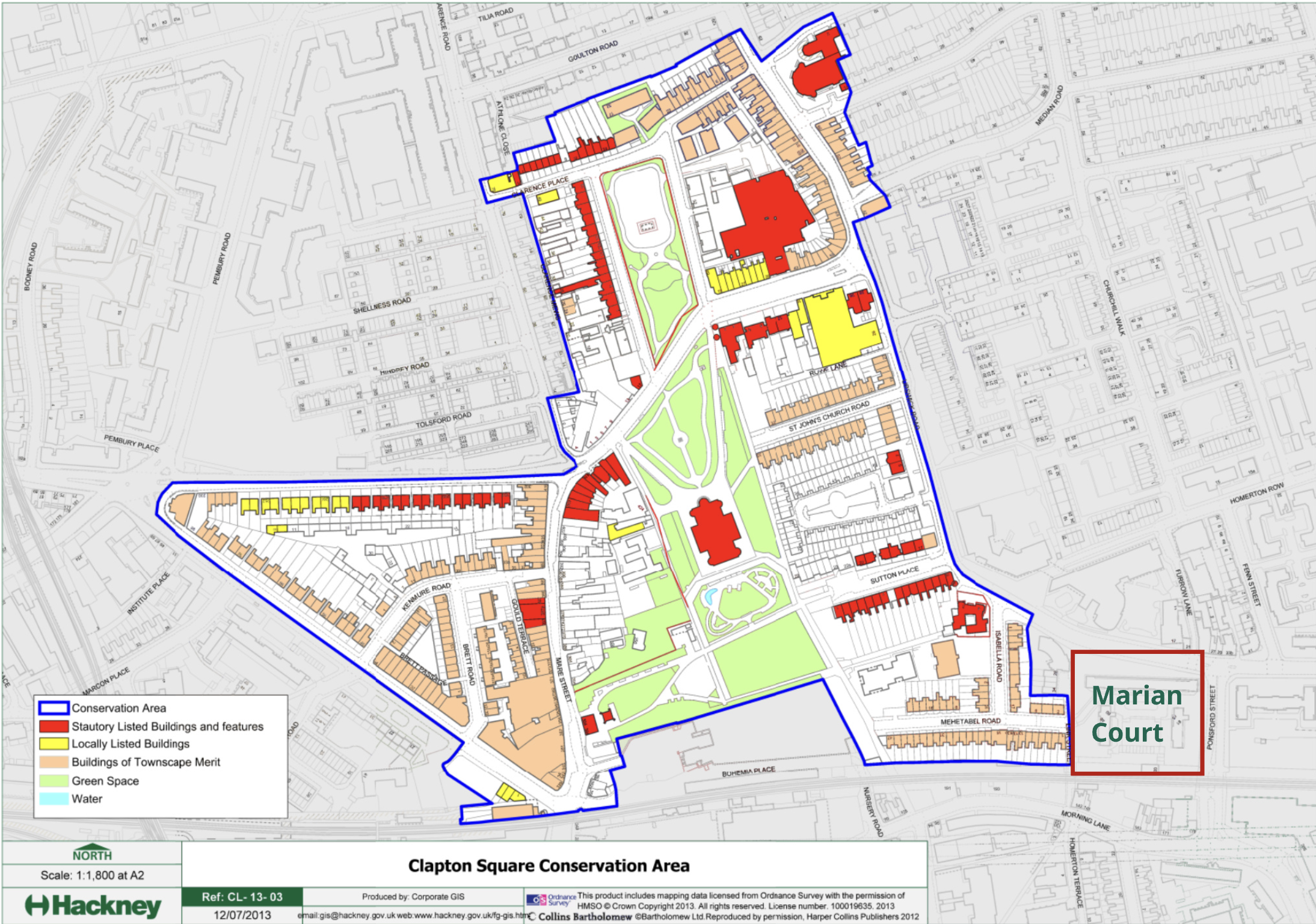
The Clapton Square Conservation Area shown above extends from the eastern end of Mehetabel Road. The reduction in height from east to west is partly due to this, and partly to the centre of the combined Bridge House / Marian Court masterplan being close to Ponsford Street. The Clapton Square Conservation Area Appraisal conducted by Levitt Bernstein Architects (LBA) has informed the massing and design of the scheme. This has been recognised in written feedback from the Conservation Area Advisory Committee.
Q5. What is the rationale for the changes in the proposed heights to Blocks A and B?
Block A
- Flats and duplexes (rather than townhouses)
- 3 roof pavilions now grown to 1 set-back storey
Why:
To make up for number of homes lost due to design inefficiencies. No perceptible change in daylight/sunlight impact for neighbours
Block B
- 1 storey added to Block B2
- Longer and wider/deeper
- Deck access introduced
Why:
To reduce number of cores and make up for number of homes lost due to additional stair and lifts in core. No perceptible change in daylight/sunlight impact for neighbours.
Block A sits on the western edge of Marian Court bordering the Clapton Square conservation area. Due to this important relationship, the height of the building has been constrained to 4 storeys. Additional volume has been added on the top floor but this is set back from the building edge to minimise visual impact.
Block B sits on the northern edge of Marian Court overlooking Homerton High Street. The additional floor is well set back from the principle facade to reduce visual impact.
All block heights have been determined with reference to London Plan and Council planning guidelines, requiring well connected sites to maximise development. As previously stated, they have stepped down from east to west to respect the Clapton Square Conservation Area and wider townscape strategies.
Q6. What is the justification for increasing the height & mass of Block C?
Block C
- Sky frame added to Block C2
- All blocks longer and wider/deeper
- Deck access introduced
Why:
To accommodate additional stair and lift in the cores. To conceal air source heat pumps on roof. Also - removes longer term dependencies on fossil fuels and offers better long range views of the tower.
No perceptible change in daylight/sunlight impact for most neighbours.
The Block C tower has needed to increase in size to accommodate the new changes to the building regulations which require a second stair and lift to all residential floors above 18m (or 6 storeys). This change has mainly been to the width of the tower along Ponsford Street to maintain a similar slim tower proportion looking onto Homerton High Street.
The number of residential floors is the same as the 2020 consented scheme with an additional story introduced at the top of the tower to accommodate air source heat pump plant to service the upgraded energy system. This top floor element is proposed as an open frame to hide the plant behind and provide glimpsed views of the sky from some angles.
Q7. What is the justification for adding 2 floors plus parapet to the east end of Block D?
Blocks D and E
- Combine into 6 and 4 storeys
- Relocate play space (basketball court)
- Deck access introduced
Why:
To reduce height below 18m overall and avoid additional lift and stairs
Justification:
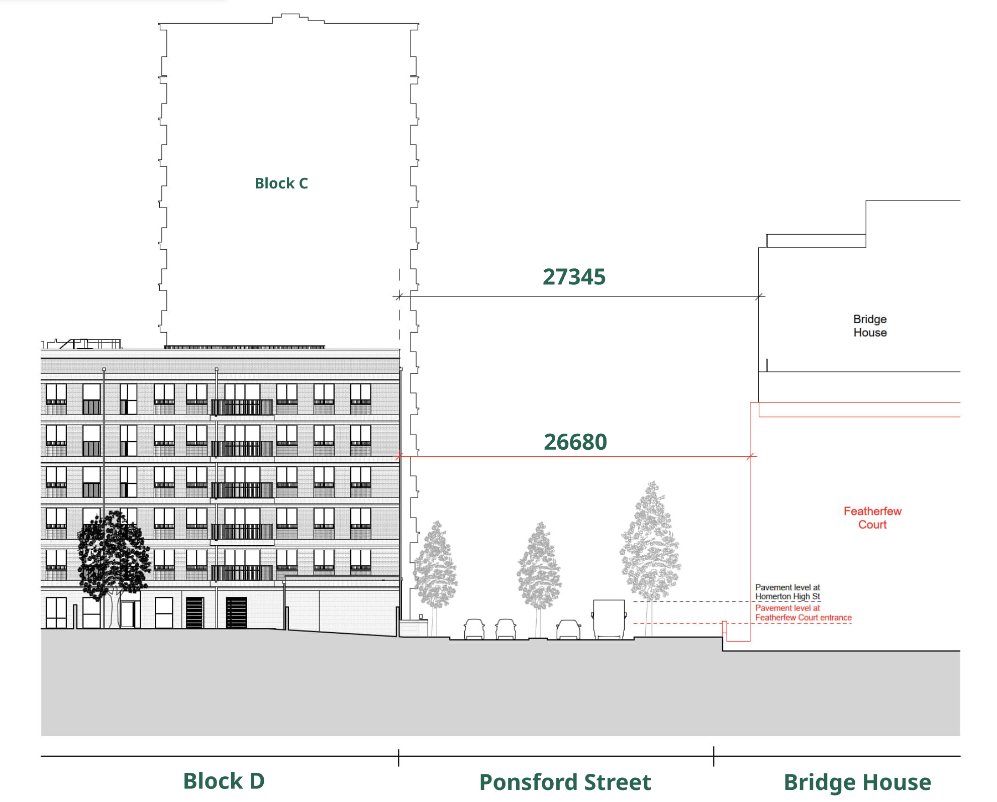
Building height is lower than Bridge House and Ponsford Street is wide enough. (See drawing below - at around 27m this is roughly 50% above 'front to front' Council requirements).
The daylight and sunlight assessments indicate that the impacts remain within acceptable planning limits, while allowing the scheme to retain the number of homes needed to support viability.
Following the 2020 consented scheme, changes to the building regulations introduced additional requirements for reasons of fire safety which included the requirement for a second stair and lift to all residential floors above 18m (or 6 storeys). The updated scheme design reduced height in some locations (Block D) to come below this threshold and also looked to reduce the number of cores (stair and lifts) across the scheme to increase efficiency and make the scheme more viable.
This reduced height has been redistributed as mass across the updated proposal including on the eastern end of Block D, with Block D therefore rationalised into a consistent 6 storey block. This was judged to be appropriate given the adjacent 6 storey height of Block C; the 5 storey height of Chervil House and the width of Ponsford Street. Recent and finalised daylight assessments (discussed further in Q8) show minimal daylight changes between the consented and proposed schemes. This places an obligation on the Council to bring forward a scheme of this scale.
Q8. What evaluations have been carried out in terms of daylight and sunlight impacts?
In order to help residents understand the differences in daylight impacts between the consented scheme and the proposed amendments an interim diagram was made available at the 'Street Exhibitions' and subsequently on the Marian Court website.
That diagram presented, in a highly diagrammatic form, the elevations of the buildings closest to the scheme and therefore those most impacted. Floor levels were shown as bands and each band was coloured to show the impacts according to an associated key.
Since exhibiting this board, the full daylight studies have been developed by dedicated daylight specialists, 'eb7' and the interim and final daylight reports were released via this project website, including further daylight tests on Furrow Lane and select Link Street windows. While the results of the interim and final studies cohere, the requirement to compare the consented scheme against the proposed amendments helps to clarify the situation in planning terms.
In short, these results show that the levels of impact between the consented scheme and the proposed amendments are predominantly below 3%, which is taken to be the threshold for perceptible change.
Given this, the Council has decided to retain the amended building heights for Blocks A, B, C and D. Not to do so would contravene regional and local policy and result in an unacceptable reduction in the provision of social and affordable housing and a challenge to scheme viability.
Q9. What evaluations have been carried out in terms of overlooking and privacy?
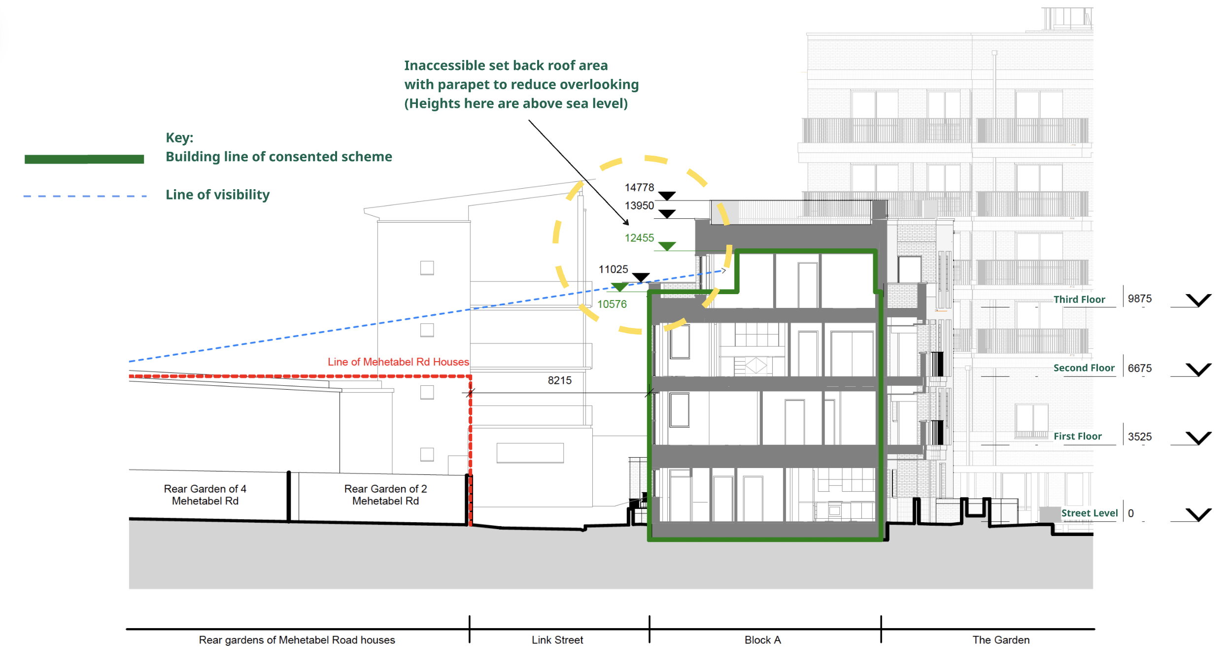
The roof terrace to Block E is not accessible to residents and therefore presents no overlooking risks. The section of Block A, below, describes how overlooking is being controlled.
The revisions for Block A have maintained the 'front' building line and end gables on the same footprint as the consented scheme. The 3 storey height of the front edge of the block along Link Street has also been maintained at a similar height to the consented scheme (450mm taller). The top floor has increased in scale but has maintained a set-back along Link Street to reduce overlooking towards rear gardens and visual impact on the street.
The 'shoulder' roof area (in the yellow dashed circle below) is proposed as an inaccessible roof. Following resident engagement, this has also been modified to be an angled roof, pitching side to side along Link Street to prevent the roof area being unofficially used by residents as a terrace.
Flats have been proposed on the lower two levels with a double storey maisonette on the top two floors which will help to reduce the number of people overlooking to the West.
The homes on the upper floors within Block A have been configured with the main living spaces (bedrooms / living rooms) facing onto Link Street and the more ancillary spaces (Kitchens / bathrooms) to the 'rear' in the same way that many of the nearby houses are configured.
Where private balconies are proposed at first and second floor levels these are recessed into the facade to reduce overlooking towards Mehetabel Road.
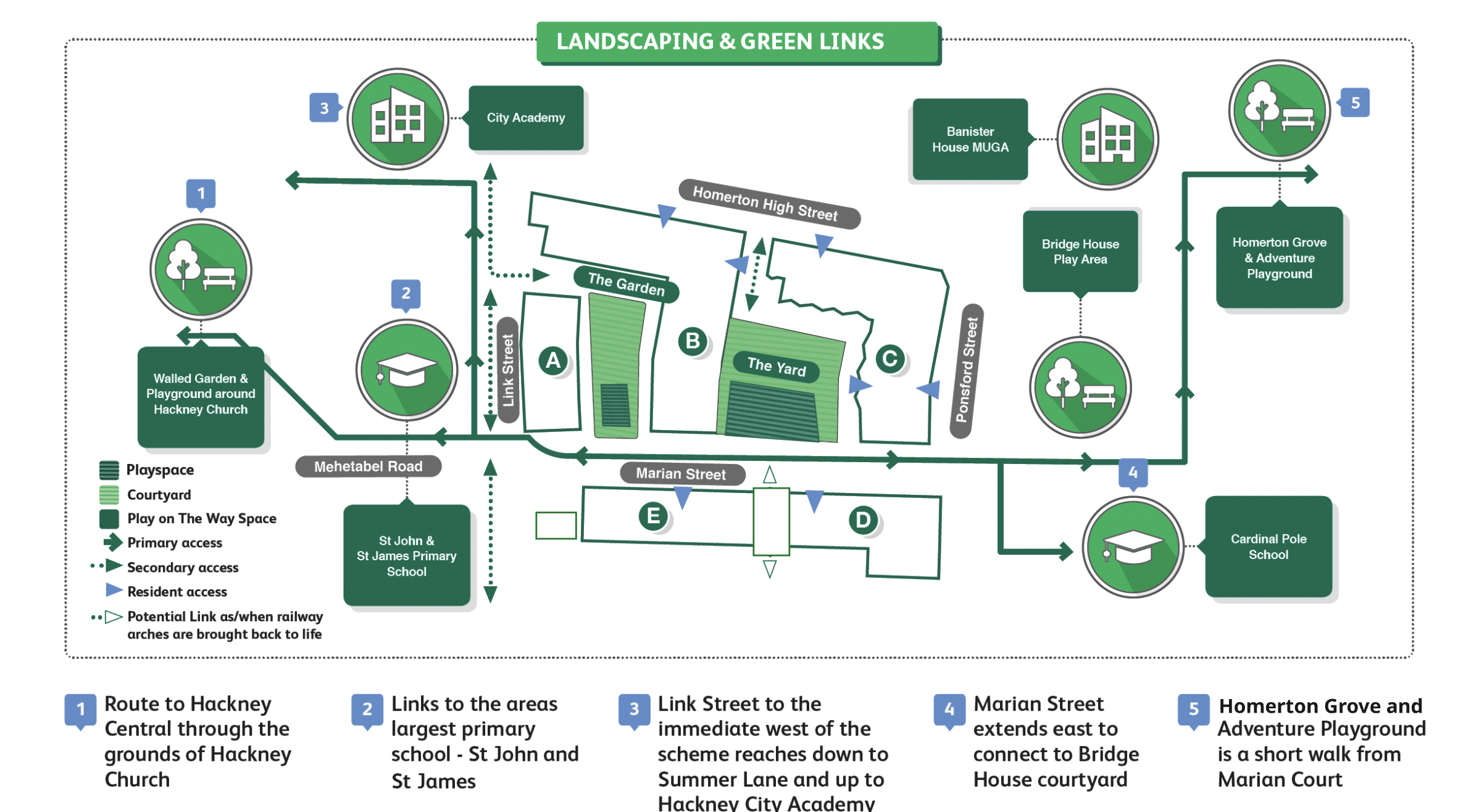
Q10. Is there a loss of permeability or accessibility through the site?
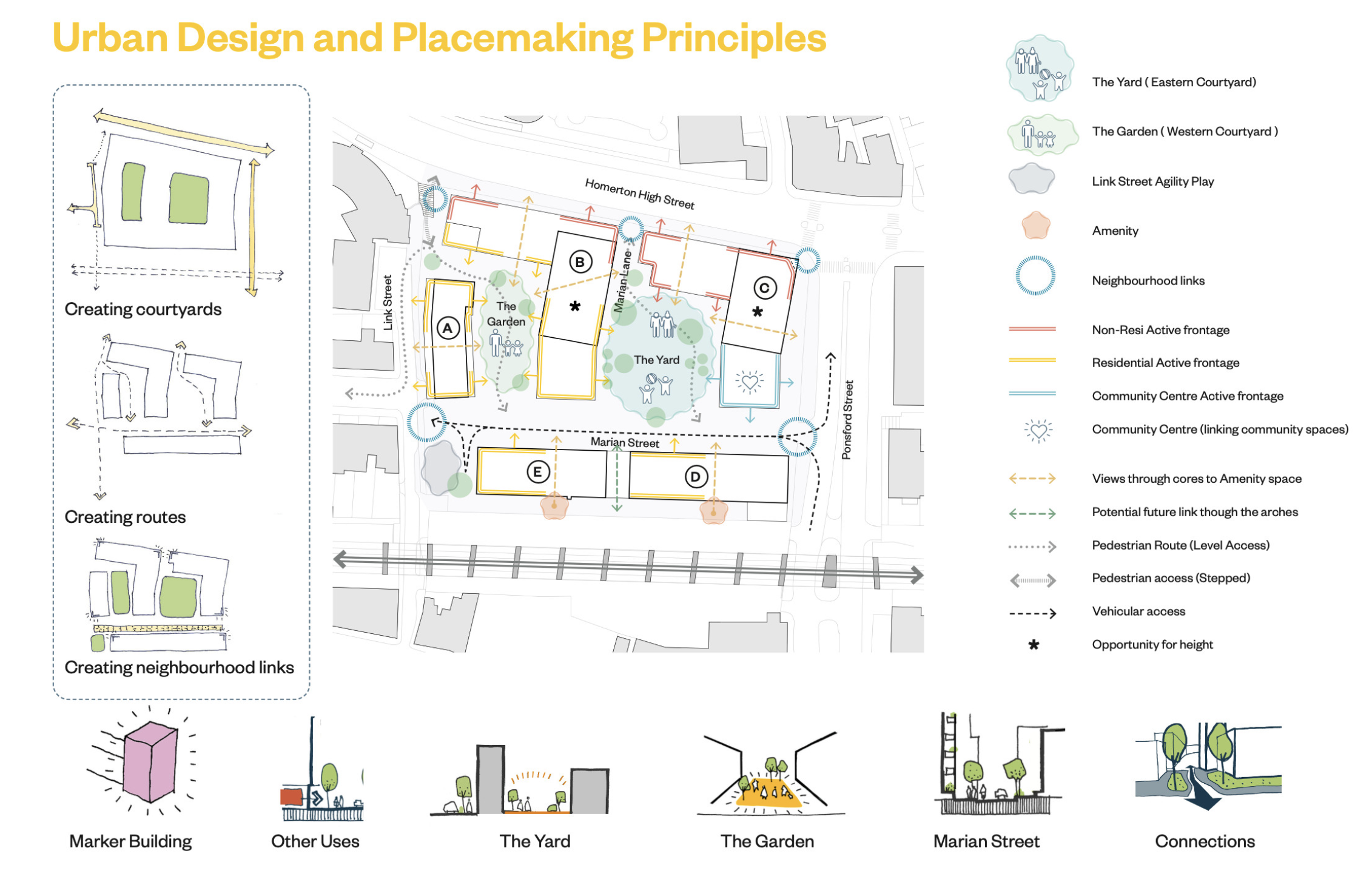
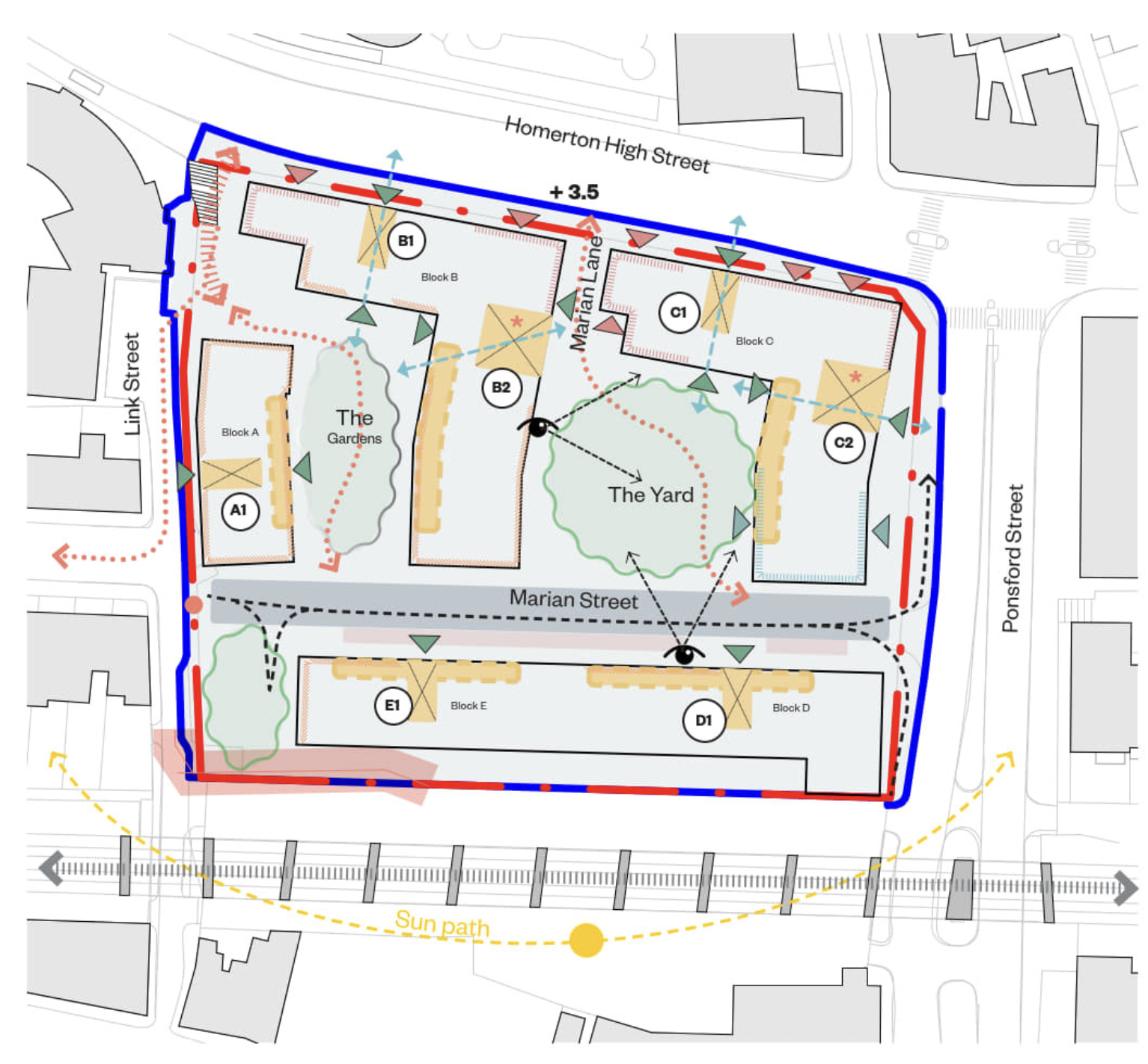
Permeability and linkages:
The diagram below describes the new routes through a site that had been previously closed to pedestrians for many years.
The new street - "Marian Street" - makes a connection from Ponsford Street to Mehetabel Road and this is lined up to connect with Bridge House (we are exploring how to further support this walking friendly route via a raised crossing over Ponsford Street - See Q 16).
The area around the new play garden for children aged 1 to 5 in the western courtyard would be accessed by steps from Homerton High Street. Link Street will be enhanced for pedestrians with an additional tree and the play-on-the way space. The proposed steps from Link Street to Homerton High Street are not as wide as the consented scheme but are two and a half times wider than the existing stairs. There is also a north-south, step-free route via a gentle ramped link from Homerton High Street to Marian Street.
The diagram below shows the key design drivers. These support the Urban Design and Placemaking Principles as illustrated below and show the commitment to permeability
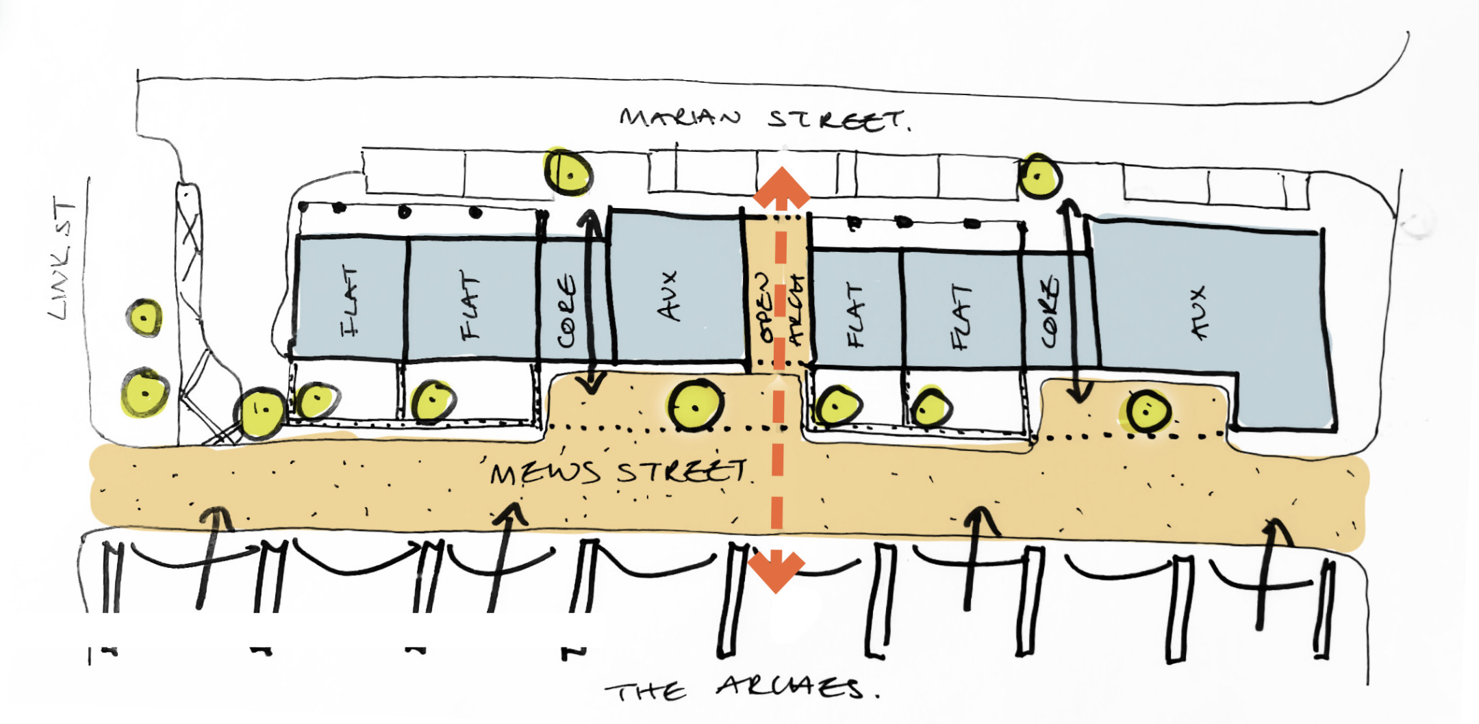
A future 'mews':
The sketch design diagram below shows how the Marian Court scheme could link to a new 'Mews Space' to the south. This would keep private garden spaces to Blocks D and E in tact while offering a new avenue to the Railway Arch Mews. The Council and its design team will only implement this connection when it is safe to do so, pending agreement from all residents and on completion of the works and letting of the arches. If these are all favourable, additional permeability could be offered via a further link to Ponsford Street via the Mews. However, the design team are confident that there is the right balance of permeability without this additional link being offered.
Q11. Will there be fewer commercial units and what changes are proposed for the Community Centre?
Fewer commercial units:
Why:
The number of commercial units is informed by commercial viability studies and advice from LBH commercial property team.
Justification:
- To reduce the risk of unlet commercial spaces
- Additional homes
- Balance of active frontage/passive surveillance still achieved
Rationale:
Ten commercial units, including affordable workspace, were offered in the 2020 consented scheme, laid out in blue in the plan below left. It was intended that this would enliven the courtyards and add to footfall. This had to be reduced to four units. The reasons for this are partly to do with viability, partly in relation to the possibility that the number of commercial spaces could lead to nuisance and noise and partly to do with concerns that it may have been impossible to let all ten units, with voided spaces being unattractive and possibly leading to a lack of footfall, natural surveillance and even, antisocial behaviour.
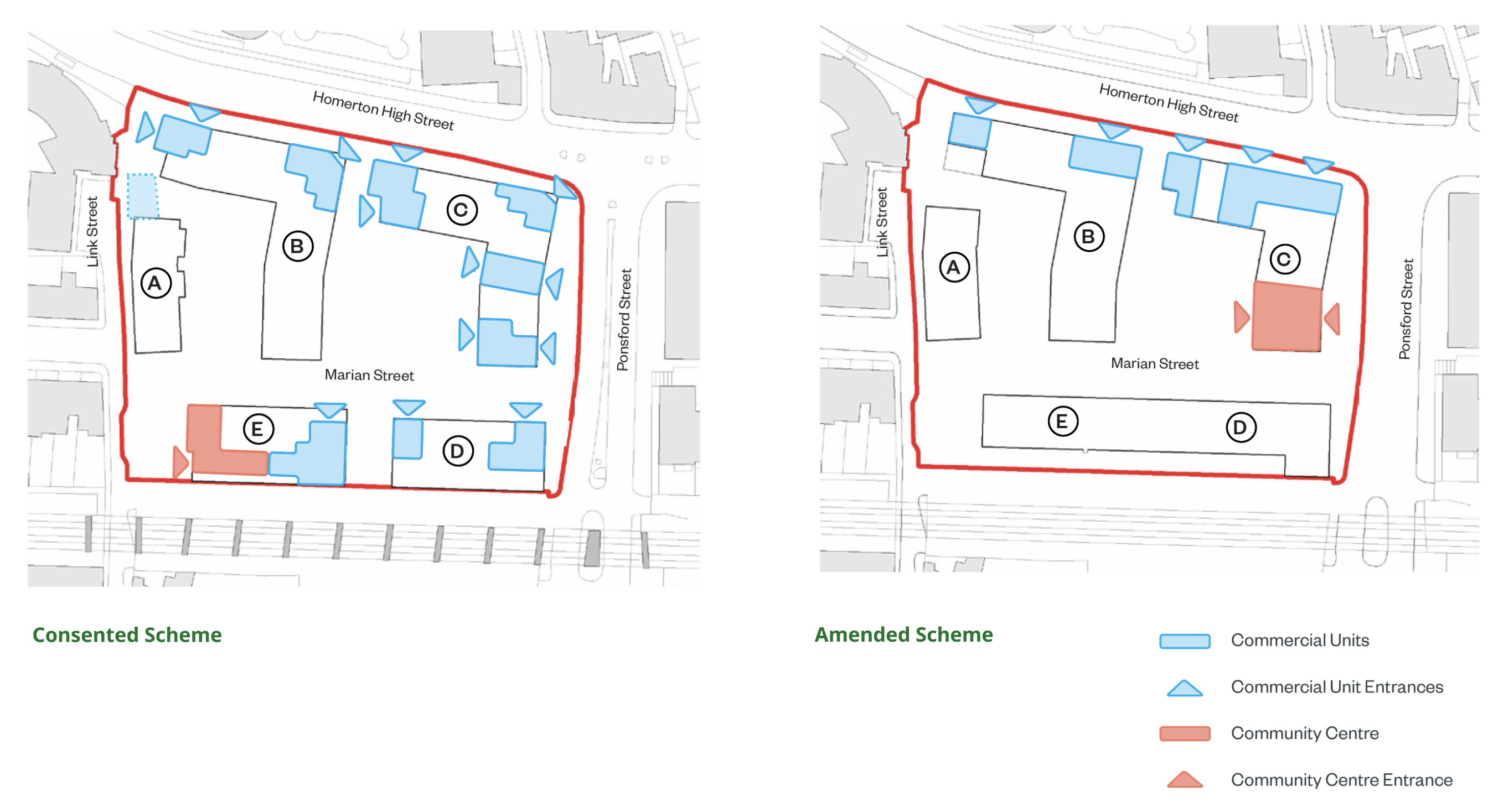
Where commercial units are retained - these are located along Homerton High Street where footfall is highest. In connection with and complementing this, the relocated Community Centre focuses community uses on internal courtyard spaces. 'The Yard' also offers the primary play space within the development, all providing natural surveillance and activity at ground floor level.
There is a possibility that the railway arches just to the south of the scheme may be let out to businesses and workshops in the medium term - (the Council have seen proposals from ArchCo, the landlords in this connection). However, if it appears at any stage that this could lead to competition and/or over-provision of commercial space, the link will not be promoted by the Council.
Community Centre
The Community Centre has been relocated from the Link Street end to the Ponsford Street end of ‘Marian Street’ to be more central to the new neighbourhood (which includes Bridge House). It will also be in a more visible and more accessible location and will have access to the 'Yard' courtyard for particular events and social occasions.
The Council wishes to develop ideas for the detailed uses of the Centre through use of a Community Working Group which the council would seek to set up at the appropriate time. If you would be interested in joining the Community Working Group, please provide contact details using the link below.
Q12. Are there changes to landscaping and playspace?
Landscaping
Replace “Cascading garden”, with a communal garden on one level
Why:
- Easier construction of basements
- Less complicated landscaping
- Additional homes at lower level of Block B
Justification:
Avoids adding height to other blocks and impact on neighbours. Level access route retained via the “Yard”
Playspace
The playspaces are integrated into the courtyards and provide a mix of landscape amenity and playspace. The west courtyard (the Garden) is prioritised for children ages 1-5 years old. The east courtyard (the Yard) prioritises 5-11+ years.
There has been a loss of a basketball area between Block D&E from the consented scheme.
In the amended scheme, playful features are retained integrally throughout the landscape, including ‘play-on-the-way’ at the Link Street corner, helping to create a more welcoming route into the estate. The corner play-on-the-way space is buffered from the vehicular turning circle by a low wall and a paved area flanks the Link Street side, where a kerb denotes where the road starts. The updated design proposals also insert a long bench at the Marian Street and Link Street junction to discourage motor scooters from cutting through this space.
Overall, the playspaces are 10% smaller than in the consented scheme. However, they provide 1055 sqm against a requirement of 638 sqm, and therefore, even as reduced, are more than one and a half times the stipulated level.
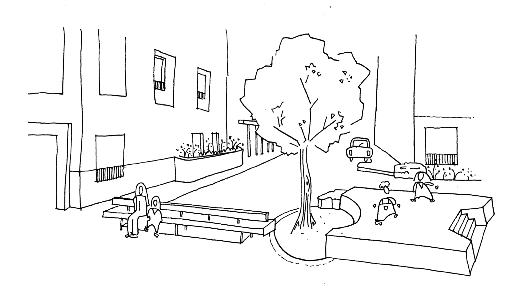
Sketch for the play-on-the-way space
Q13. Have lessons from Bridge House informed the amended scheme?
Antisocial behaviour
Landscape architects muf architecture / art point out that the large courtyard at Marian Court (the 'Yard') is around two and a half times larger than the Bridge House courtyard. In addition to this, there is the second courtyard (the 'Garden') and the 'play on the way' space at the Link Street / Marian Street intersection.
It is considered that the design will therefore provide a greater range of public and semi-public spaces, which should help reduce pressure on any single courtyard space at busy times, including before and after school.
Defensible space
The design team have carefully built in Defensible Spaces at ground level. These provide a mix of semi-private spaces, planting and level changes to provide a buffer between public and private spaces. Circulation routes are also set out that conduct the flow of pedestrians away from private spaces and direct contact with windows into residential rooms. The designs have been refined in order to reduce, to a minimum, places where antisocial behaviour could take place.
Q14 has also engaged with this question and the answer provides further information on design responses.
Flooding and Sustainable Urban Drainage systems (SUDs)
Powell Tolner Associates (PTA), a SUDs specialist, have prepared detailed proposals for the surface water drainage which consider sustainable urban drainage systems (SUDs).
In connection with this a large rainwater storage tank is proposed under the 'Yard' (the eastern courtyard). This will prevent surges of rainwater overtaxing local drainage systems. The soft planting areas also help with this.
Further consideration of flood risks have lead to proposals that constrain the provision of residential accommodation below surrounding ground levels.
General Issues
Hackney officers and design team members are also aware of issues raised as regards construction defects, faulty lifts, problematic items such overactive door-closers on main entry doors and general management issues. Although these are beyond the scope of 'planning matters', they have been noted and will be attended to in due course, as the project progresses, assuming planning permission is granted for the Section 73 application.
Q14. Could the amended layout create antisocial behaviour issues?
The amended layout has been reviewed with antisocial behaviour and natural surveillance in mind. The design uses dual-aspect entrances, overlooking from homes, active community uses, defensible space, planting and level changes to reduce the risk of poorly overlooked or ambiguous spaces as shown in the diagram below.
The Community Centre also has dual frontages with a frontage along Ponsford Street and a direct connection with and frontage onto the courtyard space. The main entrance is provided from Ponsford Street so the centre is most visible to the wider community while the primary spill-out space is arranged within the courtyard, screening existing residents to the east from potential noise. The community centre is a vital resource which additionally provides further 'overlooking' and surveillance.
The consented and amended schemes have set out to achieve well used spaces, commensurate with residential requirements for 'peaceful enjoyment of their homes' at appropriate times. The plan below shows how overlooking and movement routes have been considered from the outset to provide passive surveillance and safe spaces for the enjoyment of residents and visitors. This is closely tied to permeability considerations and to 'active frontages' whereby occupied spaces overlook public areas. The design team are confident that the layout of the Blocks, public spaces, non-residential uses and movement routes will reduce the potential for antisocial behaviour as far as is possible.
Q13 has also engaged with this question and the answer provides further information on design responses.
Q15. Are the proposed building materials changing?
Reduce extent of pre-cast concrete
Replace with high quality brick and/or reduce sizes
Why:
To reduce cost, delays and risk during construction (reliance on sub-contractors / supply chain)
Justification:
Architectural expression developed with Regeneration Strategic Design team to reflect consented scheme (see materials palette below from LBA):
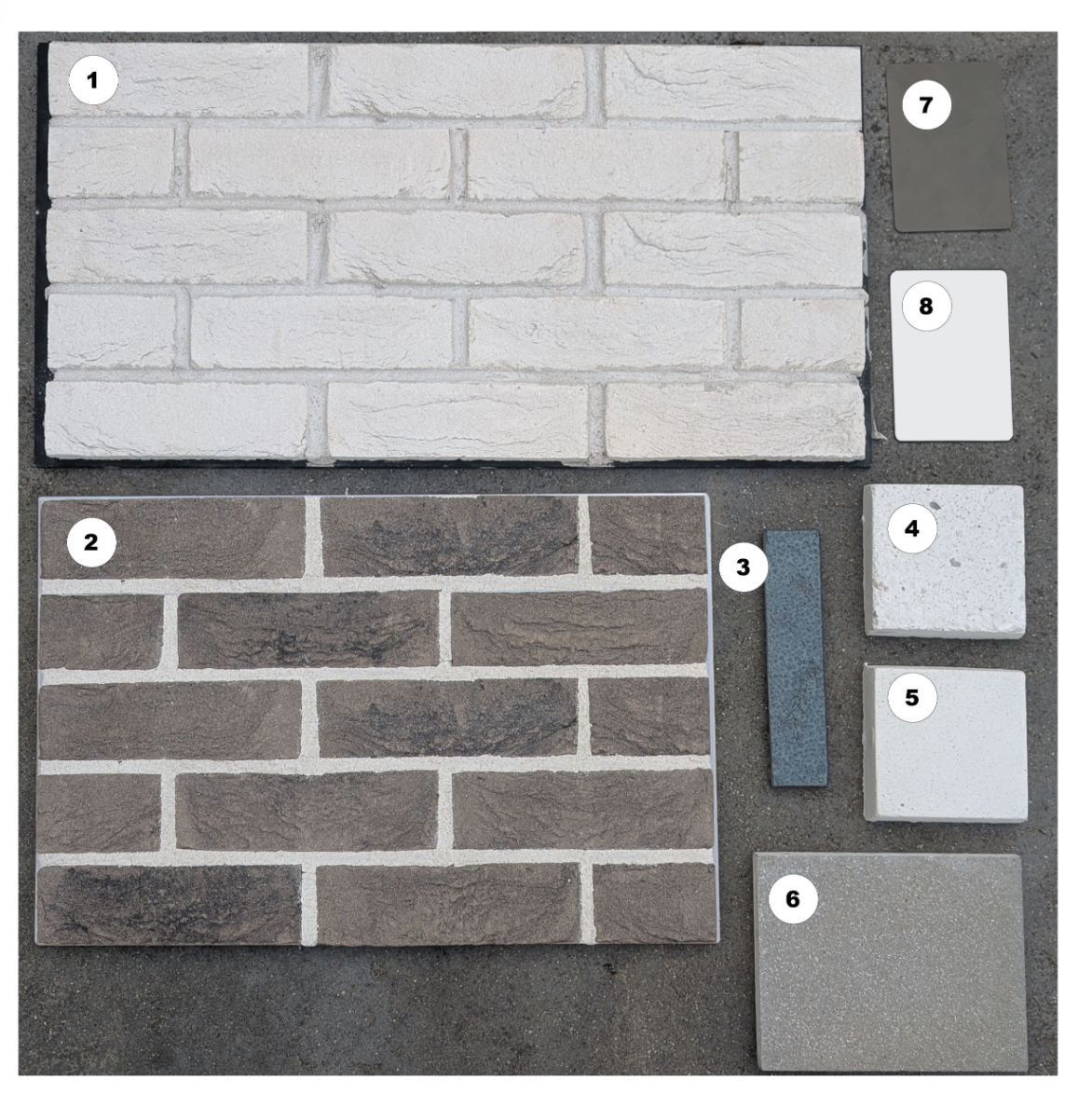
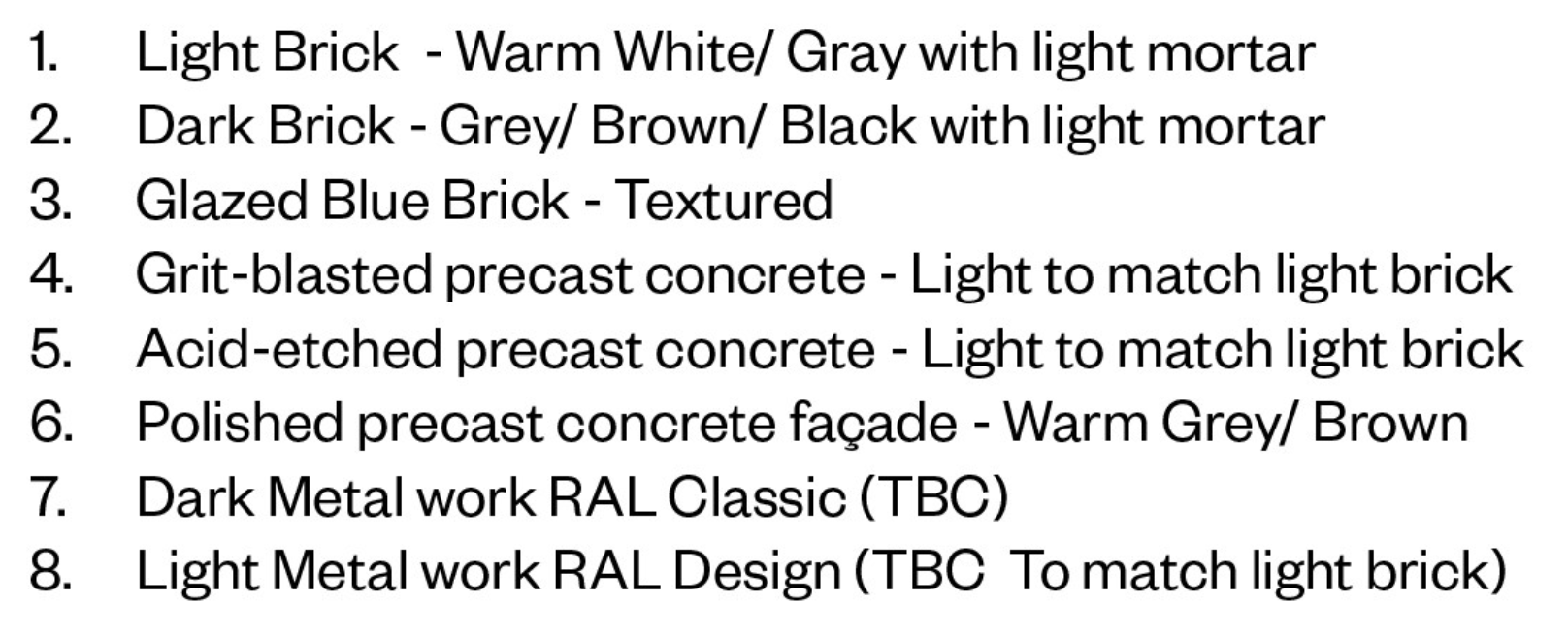
The proposed materials closely relate to the cladding materials approved as part of the consented scheme, while forming a robust and high-quality material palette. This palette will be appropriate for the modern style of new buildings while also complementing buildings in the surrounding streets, in line with recommendations within the ‘Clapton Square Conservation Area Appraisal’. The main materials are reconstituted stone, bricks, glazed bricks and light and dark metalwork.
- Precast Concrete is proposed at ground floor level along Homerton High Street / Ponsford Street and to upper floor banding around Block C.
- A light brick is proposed to Block C along with light metal to create a homogenous light facade.
- Grey brick is proposed across Blocks A,B,D,E, as per the consented scheme.
- Light brick to bases of Blocks A, D&E, and to the courtyards of Blocks B&C.
- A dark blue glazed brick is proposed instead of the tiles within the consented scheme to offer a more robust cladding solution.
- For Blocks A,B,D,E, a warmer grey / bronze colour is proposed for windows and metalwork to add warmth and work alongside the proposed brickwork
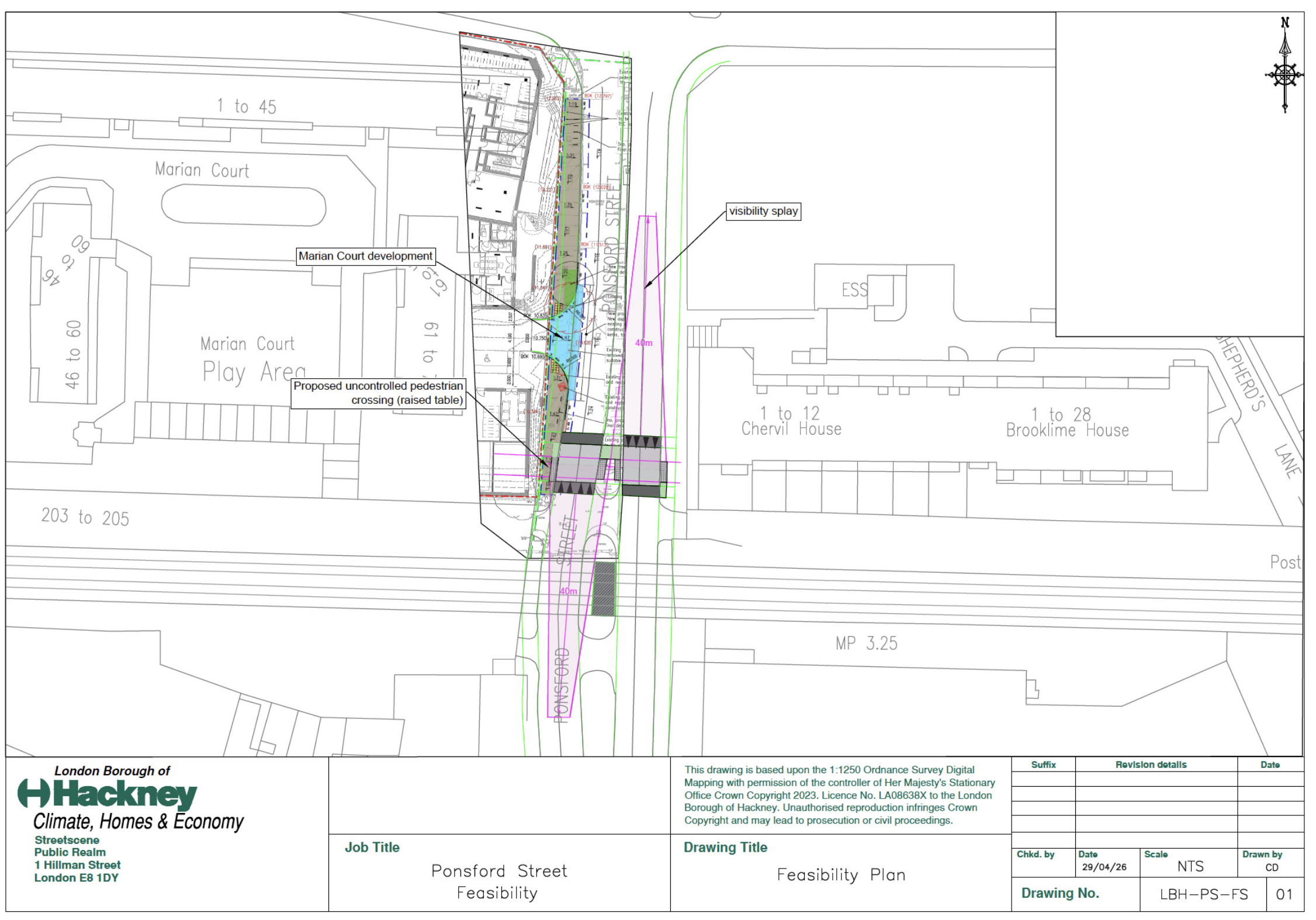
Q 16. Can a pedestrian crossing and traffic calming measures and/or cctv be put in place for Ponsford Street?
Residents have expressed strong concern regarding road and pedestrian safety and recommended that a zebra crossing linking Bridge House and Marian Court be provided, aligned with key desire lines.
In response, discussions were held with the Council's Highway team to explore the nature of crossing. Of the four options explored, the Highways team is prepared to investigate installing a raised full-width plateau crossing, raised to pavement level. A Road Safety Audit has been undertaken to assess whether this option is the safest; and to analyse impact on traffic flows (see drawing below).
The Road Safety Audit considered the vehicle speeds on Ponsford Street which often exceed the 20mph limit, and the long queues caused by heavy traffic on Homerton High Street and Morning Lane when determining the safest location and form of crossing. Existing trees were also a consideration, as they affect the visibility of the proposed crossing and, consequently, safety.
Following the audit report recommendations, the Highways team agreed on a proposed location for a plateau crossing raised to pavement level, situated five metres south of Marian Court and Bridge House. This is currently undergoing further design development. (See diagram below).
Feedback from residents also highlights the need to improve the Homerton High Street and Ponsford Road junctions. Road Safety Auditors are currently reviewing the issues and are due to report back on their findings.
Because the Ponsford Street crossing sits outside the planning application boundary, the Council will not include the proposals in the planning application. A commitment will be made in a document known as a Unilateral Undertaking. This document is an agreement and commitment to fund community infrastructure and undertake highways improvements, amongst other community-wide benefits.
Q17. How will this current engagement be conducted and what will it be able to influence?
This engagement was designed to explain the 2020 consented scheme and the proposed amendments, and to seek feedback on the areas where changes are now proposed.
Information was developed to support feedback from residents, including people who may be less familiar with design, planning processes or technical language.
The scope for change has always been clarified as relating to the proposed amendments alone.
The Addendum Statement of Community Involvement (Addendum SCI) will fully capture the consultation process and the outcomes. Answers to key questions and responses from the Council are captured here. Additional feedback gathered at this drop-in exhibition and via this questionnaire will be captured within the full Addendum SCI.
Q18. What can be done to accommodate car parking in the neighbourhood?
Policy
Hackney Council parking policy for new residential developments in high (Public Transport Access Level) PTAL areas.
Hackney Council applies one of the strictest parking restraint approaches in London. In locations with very good public transport access levels (PTAL 5–6), the default expectation is that new residential developments should be effectively car-free.
This policy is intended to:
- reduce traffic congestion,
- improve air quality,
- support walking, cycling and public transport,
- and prevent overspill parking pressure on surrounding streets.
The approach is based on:
- Hackney Local Plan policies,
- Hackney transport and parking strategies,
- and the wider London Plan framework.
Summary of policy guidance:
Highest restrictions for car parking apply in PTAL 5–6 areas (which indicate excellent public transport accessibility levels).
Most central/southern Hackney sites are affected as follows:
- No off-street parking provision expected in PTAL 5–6 areas unless specific area policies say otherwise
- Most schemes must provide little or no private parking
- Car-free development strongly encouraged and often required
- Residents are usually barred from obtaining on-street parking permits
- Car-capped development used where limited parking is accepted
- Parking numbers and permit eligibility are tightly restricted
- Planning permission - Parking oversupply can be grounds for refusal. Developers must justify any proposed parking
- Disabled parking and Accessible parking is still required for Blue Badge and wheelchair-accessible spaces are normally retained
- Cycle parking - High-quality cycle parking is strongly required
- Cycle provision often replaces car parking space
- Car clubs are encouraged as an alternative to private car ownership
- Schemes may include dedicated car-club bays
- Permit restrictions are usually secured through planning agreements/conditions and restrictions bind future residents
The key policy objective is to reduce car dependency and support “Healthy Streets”. Transport sustainability is prioritised over vehicle access
Hackney’s Sustainable Transport guidance
This states that “Parking Policy for what once used to be referred to as 'PTAL 5-6' zones (areas with very high levels of public transport accessibility levels) would not have off-street parking provision unless Area Action Plan policies stipulate otherwise.”
Hackney’s Parking and Enforcement Plan also states that:
- developments may be required to be “car-free” or “car-capped”,
- and residents of car-free developments are generally not eligible for parking permits.
Relevant official sources
What happens next
The Council intends to submit a planning application shortly. This will be a Section 73 planning application for 'minor material amendments', the planning term used for this process. The planning authority will check the submission details to establish whether it can be validated as a planning application. After that point it will invite comments under a 14-day statutory consultation period, during which you will be able to make representations. Notices detailing how to make representations will be placed in locations around the site.
You can check weekly planning applications on the Hackney website here: https://www.hackney.gov.uk/
An 'Addendum Statement of Community Involvement' will be made publicly available when the Planning Application is submitted, which will detail all of the consultation and the outcomes. It will be available through the Marian Court consultation page and the Hackney Planning Portal.
Interests
- Regeneration
Share
Share on Twitter Share on Facebook