
Green Lanes: Woodberry Grove to Petherton Road
Overview
Hackney Council is working to improve safety for all road users along Green Lanes between Newington Green and Woodberry Grove.
Between November 2015 and October 2018 a total of 51 crashes, which resulted in personal injuries, were recorded on Green Lanes between Newington Green and the borough boundary with Haringey, (excluding Manor House Station junction which is a TfL junction). The total number of casualties was 57, of which one was a fatal accident, seven were serious injury accidents and 49 were slight injury accidents. Records indicate 9% of the casualties were pedestrians, 23% cyclists, 26% motorcycle riders, and the remainder were vehicle drivers and passengers. This is despite two speed cameras intended to slow vehicles down and improve road safety.
We have developed a set of proposals that aims to reduce accidents along the road by providing a safer road layout, help with reducing the traffic speed and that also includes improvements to cycling and public realm for both local residents and road users. These proposals would be delivered in two phases. The proposals for the first phase, between Woodberry Grove and Petherton Road, are contained within this consultation document. The southern portion of the route between Newington Green and Petherton Road has a unique set of issues as it is within a shopping area – Hackney with Islington will carry out a local study on this section in the next six months. This will ensure that local concerns and issues are fully understood before the proposals are developed.
We will consult on this second phase of proposals in Summer 2020.
What is the proposed scheme?
Woodberry Grove to Petherton Road
These proposals are illustrated on the plans which can be accessed here
Primary measures required for road safety along the length of Green Lanes – these measures form the core of the scheme and are all essential for it to go ahead.
We are proposing to:
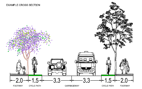
- Narrow the carriageway to encourage lower traffic speeds and make it easier for pedestrians to cross the road.
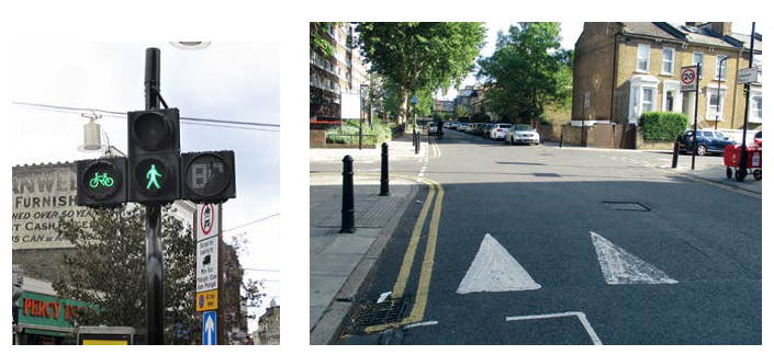
- Introduce northbound and southbound protected cycle tracks (example pictured below) on Green Lanes between Petherton Road and Woodberry Grove.
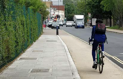 Protected cycle tracks
- Remove central islands to accommodate narrower lane widths.
- Introduce waiting and loading restrictions on Green Lanes to improve road safety and ensure smooth flow of traffic.
- Remove parking bays at locations likely to create a conflict with traffic, pedestrian and cyclist movements including the ambulance bay near Springpark Drive.
Safety measures proposed for signal junctions – these measures would enhance the safety aspects of the scheme for all road users.
The specific details on any of the locations (such as revised signal timings or layouts) may change slightly as the designs are developed.
We are proposing to:
- Upgrade the junction with Stoke Newington Church Street to include countdown for pedestrian crossings and also low level cycle signals.
- Upgrade the Lordship Park / Brownswood Road traffic signal with a low level cycle signal.
- Remove the signals at the junction with Myddleton Avenue and replaced them with a raised parallel pedestrian and cycle crossing (example pictured below).
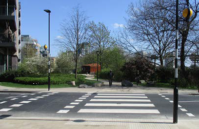 Parallel crossing
- Investigate red light and speed camera enforcement for signalised junctions.
- Review existing traffic signal timings to improve traffic flow through the junctions and provide more time for pedestrians to cross.
Measures to improve the environment for pedestrians and cyclists to move around – these would all contribute to improved safety, but also to changing how public spaces feel i.e. For example, less like a road that is simply there for drivers to pass through, but more like one that is also used by people for a variety of purposes such as visiting Clissold Park.
We are proposing to:
- Provide continuous footways (blended crossings) over side roads that prioritise pedestrians and slow traffic down (example pictured below).
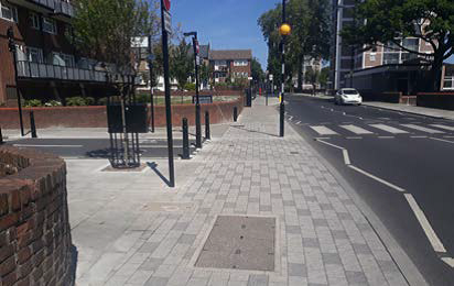 Blended crossing
- Upgrade bus stops with new “floating” style bus stops (example pictured below) to help keep bus passengers and cyclist areas separate.
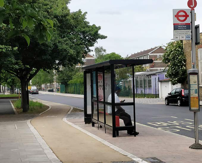 Floating style bus stop
- Install new raised parallel crossings on Green Lanes, opposite Wolfson House.
- Convert the existing three zebra crossings to raised parallel pedestrian and cycle crossings near Springpark Drive, near Greenway close and nearby Riversdale Road.
- Convert the existing pelican crossing near Gloucester Drive to a toucan crossing (example pictured below left) with a raised table (example pictured below right).
 Toucan crossing Raised table
Measures to improve the public realm – to enhance how the area feels, particularly for people walking, cycling and living there.
We are proposing to:
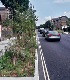
- Make public realm improvements along Green Lanes including planting approximately 35 new trees and flowers beds. The Council would carry out detailed work to identify if additional trees could be included within the scheme.
- Provide sustainable drainage systems (SuDS) at various locations (example pictured below)
Example of a sustainable drainage systems (Suds)
- Resurface pavements
- Install better and energy-saving street lighting.
- De-clutter street furniture by removing redundant posts and signs along Green Lanes and its side roads includes floating bus stops.
Floating bus stop is also known as a ‘bus stop bypass’, this is an arrangement that involves a cycle lane running behind the passenger boarding area at a bus stop, between an island and the footway.
Floating bus stops
The concept of a floating bus stop has been developed in order to separate cyclists and pedestrians where larger numbers of users will be present. In a floating bus stop, a segregated cycle lane or track continues through the bus stop area behind the shelter, thereby creating an island for bus passengers boarding and alighting at the stop. It requires a crossing (informal zebra markings) for pedestrians to access the island across the cycle track. The concept is implemented across London and other cities where new cycle lanes are implemented.
The advantage of these layouts is that buses do not have to overtake cycles between stops, and people cycling do not have to negotiate out around stopped buses. In other words, there is no conflict between bus and cycle traffic. Floating bus stops are an essential element of separating cycling from motor traffic on through routes, for comfort and safety.
Most London buses make an announcement on the approach to the floating bus stop and tell the passengers the following: “Caution. There is a cycle lane behind this bus stop. Use the crossing point”
The second phase works: between Newington Green and Petherton Road
The scheme will be delivered in two phases. The second phase works area on the plan are the road works to be delivered outside of this scheme by Islington and Hackney councils.
The next phase of consultation is likely to be in Summer 2020.
Potential interim scheme
Following reductions in our government funding, we have to seek additional funding from partners such as TfL for large-scale improvement projects like this. However, we have not secured full funding for this scheme. Should the Council not be successful in gaining full funding for this scheme, we are considering a couple of options below:
- We are proposing that, if the scheme receives sufficient support, we will implement a section of this scheme and other sections as the funding becomes available.
- The Council will implement an interim scheme which would consist of implementing advisory cycle lanes for the majority of Green Lanes on the carriageway, using lining and signing only (plus any local modifications that are required for these to be safe).
We acknowledge that Britain’s Cycling and Walking Commissioners have written to the Transport Secretary saying that painted cycle lanes are a “gesture”, however this would have the benefit of immediately narrowing the carriageway, thereby helping to reduce speeds and reduce accidents, and provide protected spaces for cyclists. The permanent scheme would then be implemented as funding becomes available.
Have your say
Please give your views by completing the online questionnaire below. We want to encourage everyone who uses, lives and works near the road to provide feedback on what they think of our proposed improvements.
During the consultation period drop-in sessions will be held at: West Reservoir Centre, Seminar room, N4 2HA, Wednesday, 04 March 2020 from 3pm to 8pm.
What happens next?
The feedback we receive at the exhibitions, by post and online will be recorded, analysed and considered carefully. Where possible, we will use your suggestions to improve our plans.
Depending on the response to this consultation, if the proposals are supported, we will start the implementation of an interim scheme early 2021, with the permanent sections being delivered over a couple of years.
We will also inform local people nearer the time as and when any works are programmed to take place.
Events
-
Drop-in sessions
From 4 Mar 2020 at 15:00 to 4 Mar 2020 at 20:00Drop-in sessions on Wednesday
4 March 2020, West Reservoir Centre, Seminar
room, N4 2HA, between 3pm to 8pm.
Interests
- Understanding views
Share
Share on Twitter Share on Facebook