
Walford Road area Road Safety and Traffic Reduction scheme
Results updated 10 Aug 2020
Thank you to everyone who responded to this consultation.
A decision on these proposals has now been made. Please visit hackney.gov.uk/walford-road-
Overview
Proposal to reduce motor traffic and improve road safety in the immediate Walford Road area
In December 2017 and January 2018, we consulted on proposals to control traffic and improve the local environment for residents and road users in the immediate Walford Road area.
Having considered the responses to the previous consultation exercise, and concerns expressed about their potential impacts on air quality, we are carrying out a new consultation on a proposal to reduce traffic and improve the safety for cyclists and pedestrians on Walford, Brighton and Nevill Roads. For Nevill Road we are talking about the section between Osterley Road and Allen Road, but will refer only to Nevill Road throughout this document for brevity.
Our proposal is one of the options that we consulted on previously, but this new consultation will allow residents to consider the advantages and disadvantages of the proposal in the light of detailed modelling of its effects on air quality.
We want to hear your views on our proposal so that they can inform a decision whether to proceed with the proposal at all or, if we do proceed with it, whether we should modify it.
What are the issues on Walford, Brighton and Nevill Roads?
In 2016, in order to improve conditions for cyclists on Cycle Superhighway 1 (CS1), three roads were closed to through-traffic at the southern end of Wordsworth Road. The closures reduced traffic, which improved road safety and air quality in that vicinity.
However, as a result of those road closures, some roads to the north of Wordsworth Road suffered an increase in traffic. Traffic on Walford Road increased by approximately 70%, traffic on Brighton Road increased by 25%, and traffic on Nevill Road increased by 55%. The traffic has increased in both directions and these figures are the combined east and west traffic counts for a full week. We think that this increased traffic was a result of drivers using these roads as “rat-runs”.
The Council’s approach for delivering traffic management schemes
We want to reclaim Hackney’s neighbourhoods from cars, make it easier to walk and cycle, and make our roads safer and more enjoyable to use for everyone living, working and visiting the borough.
However, limited funding means we can’t do everything we want to do at once. Making the borough better for walking and cycling is a continuous process.
When we implement a scheme to improve an area for walking and cycling, we monitor its effects on traffic and air quality, including in the surrounding area, and work on new schemes to improve those areas and mitigate any possible consequences.
It’s only by taking this step-by-step approach that we’ve been able to ensure that Hackney is London’s capital of cycling, where more people cycle than any other borough, and improve the borough for walking.
There has also been an increase in aggressive driving on those three roads, as a result of some rat-running drivers not wanting to give way to others.
Usually, these types of problems diminish in the weeks after changes to road layouts are made, but this has not been the case on Walford, Brighton or Nevill Roads.
Since these changes were implemented, local residents have reported a number of road safety issues.
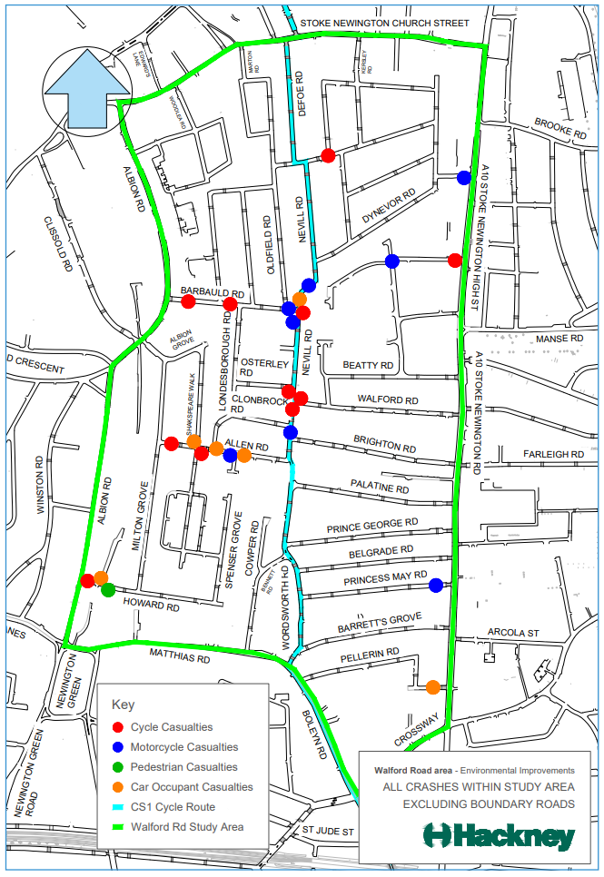
For the three years to September 2018, 30 crashes resulting in personal injury were recorded (crashes that do not cause personal injury are not recorded by the police) within the study area (the area inside the green boundary in diagram 1 below). Of these 30 crashes:
- Nine were on or very near CS1
- Two resulted in serious injury and the remainder resulted in slight injury
- Twelve resulted in cyclist casualties (of which four were on CS1)
- Two resulted in adult pedestrian casualties
- Nine resulted in motorcyclist casualties
- Seven resulted in car occupancy casualties.
In terms of the location of the cycle and motorcycle casualties, these were generally spread throughout the study area. However, there is a notable concentration of casualties in the centre of the area, on or close to Nevill Road between its junction with Dynevor Road and its junction with Brighton Road. We think that this is where much of the rat-running mentioned occurs.
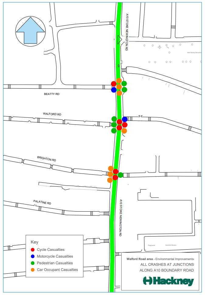
In addition a further 21 crashes resulting in personal injury occurred at the junctions of Walford, Brighton and Beatty Roads with the A10 (see diagram 2 below), with eight specifically involving vehicles turning into or out of the study area. Of these eight crashes:
- One resulted in serious injury and the remainder resulted in slight injury
- Six resulted in cyclist casualties
- Six resulted in pedestrian casualties
- Two resulted in motorcyclist casualties
- Seven resulted in car occupancy casualties.
The diagrams below show where these casualties occurred.
How are we proposing to address these issues?
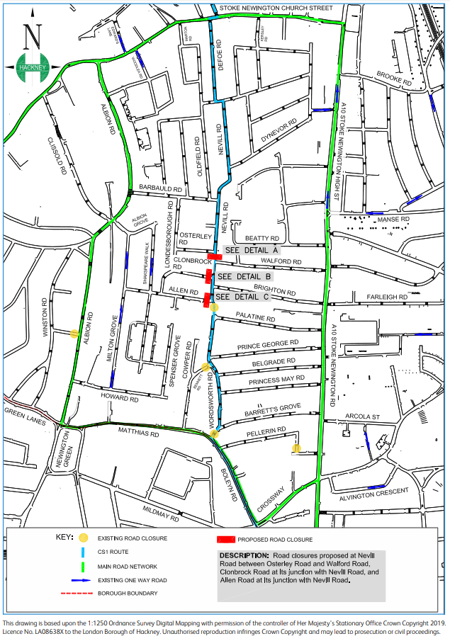
In order to tackle these issues, and promote walking and cycling along CS1, we are considering whether to implement one of the options that was put forward during the consultation exercise carried out in December 2017 and January 2018, option B.
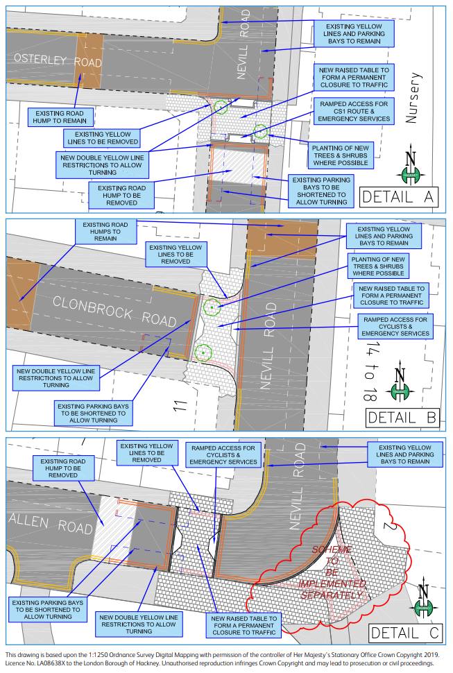
Our proposal involves closing roads to motorised traffic at the following locations:
- Nevill Road between Osterley Road and Walford Road
- Clonbrock Road at its junction with Nevill Road
- Allen Road at its junction with Nevill Road.
Under our proposal, motor vehicles would still be able to access Walford Road and Brighton Road via the A10. Access by motor vehicles to the section of Nevill Road between the closures would be via Walford and Brighton Roads only.
The main features of our proposal are as follows:
- ‘Motor vehicles prohibited’ signs would be installed at each of the junctions
- Emergency vehicles would have access in both directions at each of the road closures at any time
- Two-way movement would be maintained for cyclists at each of the junctions
- It would make it easier for pedestrians to cross at each of the junctions
- Adequate space for turning vehicles at the road closures would be provided. This would require the removal of approximately two existing parking spaces at the location of each road closure
- Access to all businesses in the area would be maintained under the proposals. As with other schemes, we would work with satellite navigation companies to ensure that changes to the local road network are captured in navigation apps and devices.
See below for location plan and detailed drawings of the proposed scheme.
Why would this proposal address the issues in the immediate Walford Road area?
Reducing traffic
If implemented, this proposal will reduce the amount of traffic on Walford Road, Nevill Road and Brighton Road, making them better for walking and cycling, especially along CS1.
Improving road safety and reducing accidents
If the proposal were to be implemented, the section of the CS1 on Nevill Road between Allen Road and Osterley Road would no longer be used as a rat-run. This would be likely to reduce the amount of traffic, reduce vehicle speeds and reduce the likelihood of crashes on or near that stretch of road.
If through traffic is reduced on Walford, Nevill (part) and Brighton Roads, the number of crashes on these roads is likely to reduce. There is also likely to be a reduction in vehicle turning movements at the junctions of Walford, Brighton and Beatty Roads with the A10, which means that the number of crashes at those junctions is also likely to decrease.
Although not an objective of the scheme, we would also expect a similar outcome on Beatty, Allen and Osterley Roads, Milton Grove, Shakespeare Walk and Barbauld Road, as much of the rat running traffic also passes through these roads.
What are the other potential consequences of the proposal?
Effects on traffic
While the proposal would reduce traffic in some roads, including roads other than Walford, Nevill and Brighton Roads, there would be an increase in the amount of traffic in some parts of the surrounding area. The tables below indicate the changes in traffic flows that are predicted to occur.
Walford Road Area Traffic Re-assignment
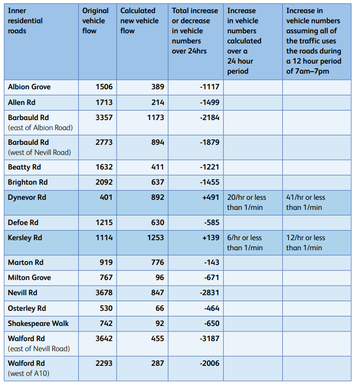
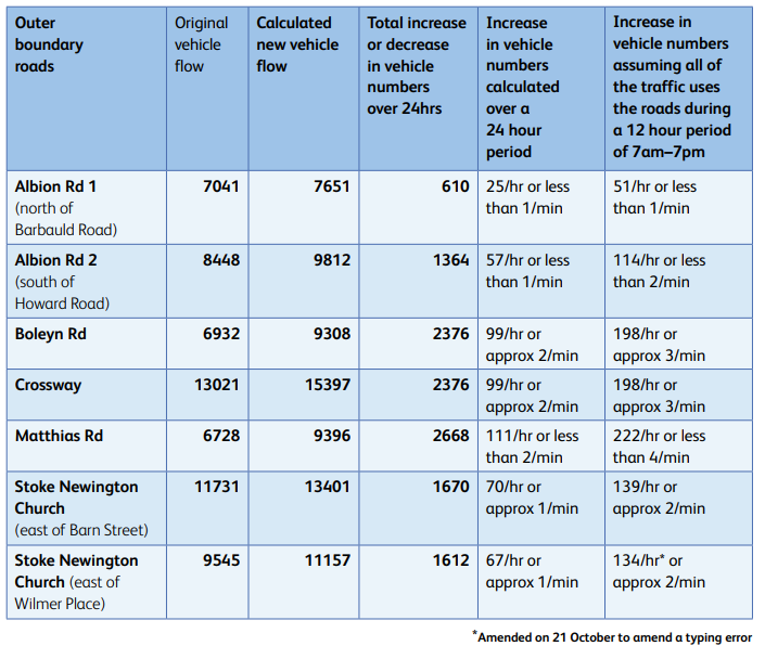
These predicted changes are based on an assumption that 10% of traffic will “evaporate”, i.e. drivers will avoid the area completely as a result of a journey becoming more difficult. This 10% traffic evaporation figure is an extremely conservative estimate based on our experience of similar schemes, such as Waltham Forest’s Mini Holland for which Waltham Forest council calculated traffic evaporation of 16%. We think this would occur because rat-running through the Walford Road area would no longer be an option.
These traffic figures are based on the assumption that the rest of the traffic that currently drives through the Walford Road area would now drive around it and still use Albion Road. In all likelihood, the actual level of traffic using Albion Road is likely to be much lower, as for example a lot of traffic going westwards is either likely to continue along Church Street if going around to the north of the area rather than turn into Albion Road.
Similarly, those going around to the south are likely to either continue along Newington Green Road or Green Lanes rather than use Albion Road. If the scheme is implemented, we will carry out a new set of traffic surveys between 6–9 months after implementation and report on traffic levels in the area.
The modelling outlined in the Walford Road Area Traffic Re-assignment tables above does not incorporate:
- Our successful bid to the Mayor of London’s Air Quality Fund to reduce polluting traffic on Stoke Newington Church Street, which, if implemented, would also reduce traffic flows on Albion Road (more information under the heading: What else are we doing to improve air quality and road safety in Stoke Newington?)
- Transport for London’s (TfL’s) proposals for the Stoke Newington one-way system, which would decrease the amount of traffic on Stoke Newington Church Street
- Any impacts as a result of the Mayor of London’s Ultra Low Emission Zone implemented in April, such as a reduction in vehicles or people changing to electric vehicles
- The future electrification of bus routes.
However, the likely effects of these measures are not yet known, and therefore we do not think that they should be taken into account when evaluating the likely effect of the proposal.
Effects on air quality
Our independent consultants, Cambridge Environmental Research Consultants (CERC), modelled the impact of these predicted traffic increases on air quality in the surrounding area. To see CERC’s report, visit hackney.gov.uk/walford-road-area
Their report is also available to read at Stoke Newington Town Hall, Stoke Newington Library and Hackney Service Centre.
As is standard practice for organisations like the Council and the GLA, we use a combination of air quality monitoring and modelling to predict air quality across wider areas. The Council has one of the largest air quality monitoring networks in London, comprising over 20 monitoring locations in the Stoke Newington area alone. Data from some of these monitoring locations fed into CERC’s modelling for the area, and were used to check and confirm the modelling.
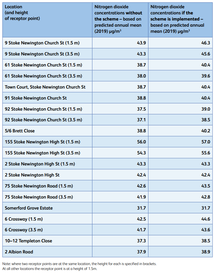
We compared the modelling to the National Air Quality Objective set by the Department for Environment, Food and Rural Affairs (DEFRA), the annual mean for nitrogen dioxide concentration, which is 40μg/m3.
This applies at sensitive locations such as residential and school buildings but not on the pavement or at shops or cafes. All other DEFRA National Air Quality Objectives for nitrogen dioxide and particulates are met across the entire area.
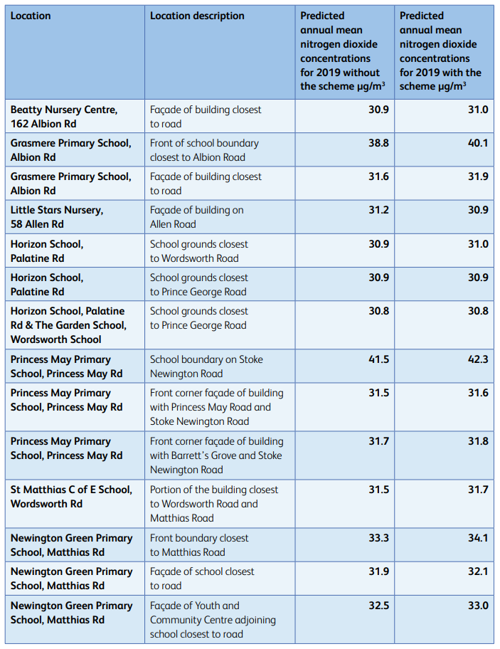
The tables below show the modelled annual mean concentrations for nitrogen dioxide at specific locations in the area with and without the proposed changes in the Walford Road area.
The modelling shows that over most of the scheme area the impacts of the proposals are positive or neutral. At roads where air pollution levels are predicted to increase, only the increases along Stoke Newington Church Street, the southern portion of Albion Road and around Crossway are considered by CERC to be significant, as they have the potential to result in additional exceedances of air quality objectives at some homes. Whether the scheme goes ahead or not, we are taking measures to improve air quality along these roads – further details of these are provided under the heading: What else are we doing to improve air quality and road safety in Stoke Newington?
Most local schools and nurseries are not significantly impacted by the scheme. Monitoring for 2018 at William Patten and St Mary’s Schools show that air quality is better than predicted by modelling and therefore air quality at the William Patten, St Mary’s and Grasmere Schools is predicted to meet air quality objectives within playground areas and at school buildings. At Princess May School, where air pollution is shown to exceed the air quality objective in part of the front playground, modelling shows the scheme will not have a significant impact on air pollution levels in the playground. Actions taken at schools, such as green screens and new gates, will improve air quality further.
The modelling does incorporate the effects of the clean air technology that Transport for London has recently fitted to buses used in the area, and the figures below incorporate the recent improvements in air quality that are predicted to have resulted from this.
*Following requests from residents for the air quality monitoring that supports this paragraph, we have sent this information out to all households in the consultation area. This letter can be viewed in the related documents section at the bottom of the consultation web page: consultation. hackney.gov.uk/streetscene/walford-road-area
Air quality at schools:
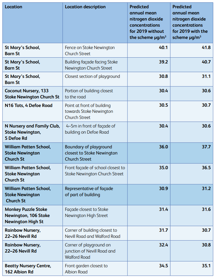
Air quality at other locations:
The Council recognises that whilst air quality would improve in some areas it would get worse in others and that therefore the scheme is not fully compliant with our Air Quality Action Plan. However, with consideration of the other actions that the Council is taking in relation to air quality and the strong competing interests of traffic impacts and road safety, the Council believes that on balance the impacts of the scheme are positive.
Other knock-on effects
It is likely that reducing the volume of traffic on Walford Road, Brighton Road and Nevill Road would also lead to the following benefits on those particular streets:
- less anti-social behaviour from inconsiderate parking and dangerous manoeuvres
- reduced noise and air pollution from vehicles and quieter roads for residents
- improvements for pedestrians with roads that are easier to cross
- a safer environment for cyclists
- reduced congestion, vehicular conflicts and driver aggression
- an improved balance between pedestrians and other modes of transport to create a more attractive neighbourhood.
If this scheme goes ahead following consultation, traffic would also decrease on Beatty Road, Allen Road, Osterley Road, Milton Grove, Shakespeare Walk and Barbauld Road.
What alternatives have we considered to address the issues identified and why aren’t we going forward with them?
Alternatives that we have considered include:
- Do nothing
In light of the issues that we have identified on Walford Road, Brighton Road and Nevill Road, we do not think that we should do nothing about them.
- Option A put forward in the December 2017–January 2018 consultation exercise
As part of the consultation exercise conducted in December 2017–January 2018, we put forward an alternative option which involved closing Barbauld Road at its junction with Albion Road and Allen Road at its junction with Shakespeare Walk. This was referred to as option A. We’re not considering this option further because even though it would have removed the majority of east-to-west traffic in the immediate Walford Road area, we think that it would have resulted in a greater increase in traffic on the boundary roads of Stoke Newington Church Street, Albion Road, Boleyn Road, Crossway and Matthias Road than the proposal discussed in this consultation document.
- Traffic calming
Walford Road and Brighton Road, as well as many other roads in the area, already have traffic calming measures (i.e. road humps or ‘cushions’). While such measures help to keep speeds down, they are not very effective in discouraging drivers from using roads at all.
- Cycle lanes
These have been suggested as a measure to help slow traffic in the Nevill Road area. However, even if parking was removed on streets in this area, the majority of roads are too narrow to accommodate cycle lanes and passing vehicles. The cycle lanes therefore wouldn’t meet TfL’s London Cycle Design Standards, which ensure safe cycling facilities.
- One-way streets
These would help reduce congestion, but are likely to encourage more drivers to use these routes as they would become easier to navigate. One-way streets also encourage drivers to drive faster.
- Banning turns at the junctions of Walford Road, Brighton Road and/or Beatty Road with the A10
This measure would be expected to reduce accidents related to turning movements at the junctions, however it would not substantially reduce traffic passing through the area.
- Timed closures enforced by cameras
Timed closures which are only in place for part of the day are an alternative to permanent closures. The Council has used them in the London Fields area and where the closures can be targetted to be in place during the periods when the problems are occurring.
Walford, Brighton and Beatty Roads experience problems with traffic more frequently in the traffic peaks and at weekends. The operating times would therefore need to be different on week days to weekends. This would mean that the signs would need to be large to accommodate this information, but we also think that this would be confusing to drivers.
An alternative proposal for timed closures of approximately 6pm to 7.30am (i.e. broadly ‘night time’ hours) has been suggested to the Council for consideration. We have reviewed the data and do not believe that this would address the majority of problems in the area. For example, between 54–62% of the crashes occurred during the ‘day time’ hours and approximately 65% of the traffic flows were recorded during the ‘daytime’ hours. The suggested times would also not address the safety issues experienced by cyclists, as the peak periods for commuting are between 7–10am and 4–7pm. For these reasons the Council has rejected this proposal and the use of timed closures.
- Use of passing spaces
These have been implemented in Walford Road, however it is reported that they are being used by delivery vehicles and there are too many cars trying to get into them at the same time. They have therefore not been effective in ensuring that vehicles give way to each other in turn.
- Waiting until the ULEZ is expanded to Hackney in 2021
The Council lobbied TfL successfully to expand the ULEZ to cover the whole of the borough and are expecting this to be implemented in 2021. However, rat-running by cars, vans and trucks is having a significant impact on residential streets like Walford Road now and is resulting in road safety issues where people are getting injured. In addition, if the Stoke Newington gyratory proposals are implemented, they are predicted to push more traffic onto Walford Road, Nevill Road and Brighton Road. We don’t think that waiting until the ULEZ is implemented is an option. We are working with TfL on their proposals for the gyratory.
What else are we doing to improve air quality and road safety in Stoke Newington?
We are also taking the following steps to help tackle localised air pollution and road safety:
- We have won funding from the Mayor of London to improve air quality and promote walking and cycling in Stoke Newington. The funding could see the introduction of electric charging points, a cargobike hire scheme and improvements to public spaces to encourage walking and cycling, alongside anti-idling measures at the A10 junction with Church Street. Subject to engagement with local people which started before the summer and will continue into the autumn, the bid will also investigate the introduction of measures to restrict polluting traffic on Stoke Newington Church Street. We will try to ensure that any measures to restrict polluting traffic on Church Street would also reduce traffic on Albion Road, which is classified as the same ‘B’ road, the B104.
- The Mayor of London’s Air Quality Fund has approved our bid to expand our Zero Emissions Network, which supports residents and businesses to reduce their emissions, to Stoke Newington
- We are installing green screens at St Mary’s and Grasmere Schools, as part of a borough-wide initiative to introduce green boundaries at schools. A green screen has already been installed at William Patten School and new gates will be installed shortly
- We are monitoring the front playground of Princess May School to confirm whether the annual mean objective is exceeded within the playground, and will install a mobile monitoring station within the playground to estimate pollution levels during school times
- We will also be enhancing the green screen on the A10 fence line at Princess May School
- We are investigating whether we can introduce additional road safety measures on Stoke Newington Church Street at St Mary’s School
- We are introducing School Streets at St Mary’s and William Patten to encourage children to walk and cycle to school, reduce congestion and improve air quality on those streets
- We supported Grasmere School in moving the school entrance away from Albion Road to reduce children’s exposure to pollution (completed in 2018)
- We are continuing to ask that TfL move the bus stop outside William Patten further away from the school, which would improve air quality at the school
- We are widening footpaths and planting trees on Crossway.
Further information
Copies of the Air Quality reports will also be available for viewing at the following locations, if you do not have access to a computer:
- Stoke Newington Library, 182 Stoke Newington Church Street, N16 0JL
- Stoke Newington Town Hall, Stoke Newington Church Street, N16 9JP
- Hackney Service Centre, 1 Hillman Street, E8 1DY.
What happens next?
We will publish the consultation responses as well as the decision made, at consultation.hackney.gov.uk
If, following this public consultation, the Council decides to proceed with this proposal, a statutory process will be carried out to implement it. If approved, it is anticipated that the closures could be implemented by March 2020.
If the proposals are implemented, we will carry out a new set of traffic surveys between 6–9 months after implementation and report on traffic levels in the area. We will also continue to monitor air quality in the area. To keep up to date with this and other plans, please visit hackney.gov.uk/street-consultations
Events
-
‘Drop-in’ session
From 24 Sep 2019 at 15:00 to 24 Sep 2019 at 20:00‘drop-in’ session on Tuesday
24 September, Stoke Newington Town Hall,
London, N16 9JP, between 3pm to 8pm, where
you will be able to ask questions directly of
Council Officers.
Interests
- Understanding views
Share
Share on Twitter Share on Facebook